
Introduction
Sundarbans is a part of the largest delta in the world which is formed by the rivers Ganga, Brahmaputra and Meghna. The region is a swamp adjacent to both the plains and the sea and is intersected by several river tributaries, creeks and canals. Although the topography makes the region unconducive for habitation, it is densely populated, with villages spaced around the edges of the forest. Its mangrove forest acts as a natural flood barrier, protecting the coastal population from the devastating impact of cyclones that hit the region (Vermaat and Thampanya 2006). However, increased deforestation and damage to the mangrove forests for extraction of resources, which are high in economic value, is not only leaving the coasts progressively exposed and more vulnerable to storms, but also depleting the rich biodiversity of the region.
Biodiversity of the Sundarbans
The Sundarbans is one of the largest mangrove forests in the world and takes its name from the dominant mangrove species, Heritiera fomes, locally known as sundari tree. Mangrove forests are biologically productive ecosystems and Sundarbans, too, is home to a very rich floral and faunal diversity. The region encompasses 85 per cent of mangrove habitat in India with 63 of 69 mangrove species found in the country (Danda et al. 2011). The algal flora of Sundarbans has not been examined in detail, however, a total of 150 species has been identified in a recent study in the Indian part of Sundarban (Naskar et al. 2004).
A total number of 1,434 faunal species has been recorded, despite fragmented record of most faunal group in the region (Das and Nandi 1999). The rich estuarine and coastal marine life on the Indian side of the forest consists of 165 species, which includes hilsa (Tenualosa ilisha), spotted javelin fish (Pomadasys hasta) and others (Sanyal 1999). Seven amphibian and 59 reptile species are also present that include king cobra (Ophiophagus hannah), Indian spectacled cobra (Naja naja), Indian python (Python molurus), olive ridley turtle (Lepidochelys olivacea), green turtle (Chelonia mydas) and others (Naskar et al. 2004). Several species of kingfisher, white-bellied sea-eagle, herons, egrets, storks, sandpipers, etc., are the water fowl common in the region. Forest birds like woodpeckers, barbets, shrikes, drongos and others are also abundantly found. The Sundarbans support one of the largest population of tiger (Panthera tigris), spotted deer (Cervus axis) and wild boar (Sus scrofa) that occur in large numbers and form the principal prey of the tiger (Gopal and Chauhan 2006).
Sundarbans: History of the ecosystem
The mangrove forests of Sundarbans have an extended history of conservation and management, crucial for understanding present-day conservation challenges in the region. Evidences of human ingress, in the form of proto-urban settlements, dating back to the Mauryan period, have been highlighted in discussions of Sundarbans’s history (Pandit 2013). The Mauryan Empire, which encompassed most of the Indian sub-continent in between 321–226 BC, laid emphasis on management of forests classifying them based on their intended use. The Sundarbans was also a part of the forest area managed by the empire. However, this management system was not followed during the Gupta Dynasty (AD 320–415), when extensive tracts of land were cleared and converted into agricultural land.
The narrative of reclamation of land becomes stronger in the pre-Mughal era which can be dated back to before the rule of the Muslim–Indo Turkish, from AD 1204 to 1575 (Townsend 1987). During this time, the region is known to be inhabited by the Hindu Bengali caste of Pod in the west and Chandals in the east, who practised fishing as livelihood. However, it is believed that Muslim holy men, who established the Islamic religion in parts of Bengal in between the thirteenth and the eighteenth century, played a significant role in the intensification of wet rice cultivation in Sundarbans in the thirteenth century, thus contributing to altering the natural forest ecosystem (Eaton 1990).
There are accounts of abandonment of the region due to floods that led to dislocation of many villages in 1584. Depopulation is believed to have continued in the following years and the region was overrun by forests. While some attribute it to Portuguese and native pirate incursions, narratives on shift in the river course, leading to increased salinity of the agricultural land, are also present (Chakrabarti 2009).
After coming to power, the East India Company appointed Commissioner William Dampier and Lieutenant Hodges to survey and identify the boundaries of the Sundarbans forest in 1764. Hodges divided the forest into 236 blocks, which in total measured to over 1.7 million acres. This provided the British with a picture of tracts of land that were not under the government’s lease, thereby presenting them the complete potential of Sundarbans as a revenue yielding area. With alluvial land in the river delta, the region had high economic potential, which prompted the company to convert the ‘wasteland’[i] into paddy land.
They initiated attempts for reclamation, by converting the forests into agricultural land, with the help of Bengali zamindars, incentivising them in the form of land tenures. While earlier, only bhawalis (the woodcutter community of Sundarbans) had the right to extract timber from the forest without paying revenue to the government, to contribute in land reclamation, forests were added to the common pool resources, bringing in people from agrarian and fishing communities as well, in timber extraction. These communities consisted of both Hindu tribes and Muslims (Danda 2007). The tribes that were primarily brought in for reclaiming the land, settled in large numbers on land that was prone to flooding and cyclones, adopting subsistence methods for living that had an adverse impact on the environment (O’Donnell and Wooden 2015).
The process of reclamation continued well into the nineteenth century, until Sundarbans was declared a protected forest in 1878, which marked restriction of the use of forest resources in certain areas. In the meantime, the government continued leasing land for cultivation, which ensured the inflow of revenue. The legal restriction on the natives to extract resources was used by the government as an opportunity to secure and upgrade their stock of various kinds of timber.
Nevertheless, reclamation of land in the nineteenth century emerged as a daunting task, as local tigers, branded as man-eaters, attacked defenceless forest clearers. In some places, work had to be given up, and when this was for an extended period, the cleared land would revert to being a forest (Bacon 1837). A policy for reward was adopted by the government to induce indigenous shikaris (hunters) into killing tigers. This led to large-scale slaughter of tigers in Sundarbans between 1881 and 1912, when more than 2,400 adult tigers were killed in the region (Chakrabarti 2009).
Sundarbans, in the subsequent years, interestingly emerged as an insurance provider against unanticipated downturns. The region provided food grains to distressed areas during the famine that hit Bengal in the nineteenth century, and sheltered many immigrants from central and east India (Mukherjee and Tiwari 1984).
Sir Daniel Hamilton, a Scottish businessman and visionary, aiming for rural reform in Sundarbans, founded a utopian settlement in 1903 that welcomed people from all castes, creeds and ethnicities. He worked on rural upliftment through reconstruction programmes and established a co-operative society. Rabindranath Tagore, who was a close associate of Sir Hamilton, is also known to have stayed in the Sundarbans in 1932.
The famine in AD 1943 and independence of India from British rule, both contributed in intensification of agriculture in the 1940s. With Independence, Bengal was divided into two parts, West Bengal and East Bengal (present-day Bangladesh), dividing the Sundarban area and leaving 40 per cent of the forest as part of West Bengal. This period saw movement of people from East Bengal to the Indian side of the forest and vice-versa. Following the abolition of the zamindari system in the 1950s, the ryotwari system was introduced, where the land was now leased directly to the peasants. This brought about a new vigour for transforming the forests into agricultural land, increasing siltation of the river islands that lead to significant decline in fish life.
The deterioration of forest and biodiversity that took place over this period by focusing primarily on agriculture, eventually had an adverse impact on the biodiversity, which have been realised many years down the line with the disappearance of species indigenous to Sundarbans (Mukherjee and Tiwari 1984).
Significant increase in the human population on the Indian side of Sundarbans has been documented following the 1971 Bangladesh war for sovereignty, when the population rose from 2 million in 1971 to 4.1 million in 1981 (Census 2001). This can be attributed to the increased influx of refugees from East Bengal to settle in the inhabited villages of Sundarbans, where their relatives and neighbours had migrated to before Independence.
The Sundarbans, home to a considerable population of tiger, came under tremendous pressure due to the degradation of the tiger habitat with the increase in human population. To protect the habitat of the national animal, Sundarbans was declared Sundarban Tiger Reserve in the year 1973, by the Government of India. Although this renewed efforts for conservation in Sundarbans, it also became a cause of conflict with the refugees who intended to settle in the periphery of the protected area. In 1978, thousands of refugees in the village of Marichjhanpi, one of the forested islands of Sundarbans, were brutally evicted by the authorities for violating the Forest Act (Jalais 2005). While this was an attempt to prioritise conservation of the habitat, the decision was met with a lot of criticism for relegating the already marginalised against tigers, the national animal.
Unregulated alteration to the forest ecosystem, with increased forest area brought under human settlements and agricultural land, along with construction of embankments, triggered a number of extirpation (local extinction) and contraction of habitat for several species, over the period. The species now known to be extirpated from the region are: the water buffalo (Bubalus bubalis); the swamp deer (Cervus duvaucelli); the Javan rhinoceros (Rhinoceros sondaicus); the gharial (Gavialis gangeticus); and the chitra turtle (Chitra indica) (Danda et. al. 2011, Sanyal 1999). The barking deer (Muntiacus muntjak) is also possibly locally extinct as it was last sighted in the 1970s (Sanyal 1999).
Degradation in the biodiversity, quality and the area of Sundarbans have forced the realisation that the forest is an exhaustible resource, leading to initiatives for its conservation. Today Sundarbans is a National Park, Tiger Reserve and a Biosphere Reserve. It was also included in the World Heritage Sites in 1985 by UNESCO.
Human habitation
Sundarbans is the world’s largest prograding delta, intersected by a complex network of tidal waterways, mudflats and small islands where salt-tolerant variety of mangroves grow. Permanent habitation is sparse given the complex physiography of the region, with forest covering 70 per centof the region. Out of the 102 islands in the Indian part of the Sundarbans, only 54 islands are currently inhabited. These islands in the periphery of the protected area, have villages with houses on raised platforms supported by 3-5 meters high poles, built of bamboo or wood from the forest. Surrounding the islands, there are embankments built to prevent erosion and keep the saline water from entering the inhabited area.
Embankments have been discussed as a crucial part of inhabiting an island or a deltaic region, where the islands are created by silting of the intervening channels to form a raised platform, permanently above the high water level. However, during the process of land reclamation in Sundarbans by the British, this process was hastened and the land was reclaimed at the limit of low water level with the help of embankments placed differently. In consequence, the silt that would have otherwise deposited on the island raising its height, deposited in the creek, raising the level of the creek bed higher than the low-lying reclaimed areas, converting them into permanent marshes (Mukherjee 1969).
Further, to prevent the land from transforming into permanent marshes, new embankments were built. This is debated as a cause of increased inhabitability of the low-lying land tracts in Sundarbans. Where Bhattacharya (1998) claims that the 'embankments sealed off the possibility of these tracts ever naturally maturing into lands habitable by humans', Hunter (1875) argues that if it were not for embankments, maintenance of human habitation in Sundarbans and practice of agriculture would not have been possible.
In Sundarbans, the zamindars who leased lands from the British followed a system of land reclamation where they first embanked the land to keep the salt water out, then cleared the forests, to create space for tanks for water supply and storage along with huts for the workers. Rice was planted immediately to keep the land from being overrun by reeds. These embankments built by the zamindars were private properties built in unscientific ways, using material that was unsuitable for the soil and required regular maintenance (Sarkar 2002; Bhattacharya 1999). For the construction of embankments, migrant labour was brought in from adjoining districts of Midnapur and from central India (Iqbal 2011). In the 1830s, several Santhal villages sprung up on the periphery of marshy Sundarbans (Dasgupta 1984). These migrants are represented by their descendent generations in today’s population.
After the abolition of the zamindari system, the embankments became public property, and their maintenance went down in the absence of a sufficient budget with the state government. The embankments were weak and, over time, collapsed under the force of nature, causing saline water incursions in the agricultural fields. Culturally, a section of the population regarded practice of agriculture as a respectful occupation, and the inability to produce their staple crop impacted the household negatively. A study conducted by Danda (2007) shows that 67 per cent of the households that adopted fishing and other water-based livelihood activities, following the collapse of the embankments, were living in conditions worse than before.
Interestingly, a correlation can also be drawn between the breach in the embankments and intensification of human pressure on the environment. With collapse of every embankment, pressure on the global common pool of resource, which in the case are the resource from the forest and avifauna diversity in the creeks, increases, posing a direct threat of degradation (Danda 2007).
However, the vulnerability of the population in the Sundarbans is not only attributed to the breach of embankments. In addition to the ecological challenges faced by the people, subdivision and fragmentation of landholdings through property division or land erosion, high percentage of landless labourers, frequent seasonal variations, climatic incidents leading to crop failure, high human-animal conflict and other issues contribute in further marginalising the population (Debnath 2013).
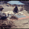
Sundarbans is a severely underdeveloped region with poor infrastructure facilities, poor communication and transport networks as well as poor and inadequate healthcare facility (Chowdhury et al. 2008). Hence, of the 4.1 million (based on 2001 census conducted by Government of India) people settled in Sundarbans, 32 per cent are dependent on the resources of the forest, directly or indirectly. They are mostly communities that have been traditionally practising the main forest-based livelihoods, which has been classified below:
Fisherfolk (Jele)
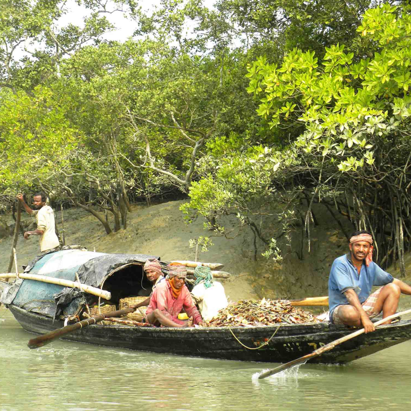
Fishing in the creek and rivers is practiced by the communities settled on the fringe of the protected forest area, and communities living along the coastline go into the sea for fishing. Fishermen, referred to as jele locally, are known to use both traditional methods and motorised boats for fishing. Fishing in the Sundarbans comes with its share of occupational hazards which include encounters with predators and unfavourable weather conditions (Chowdhury et al. 2008).
Woodcutters and firewood collectors (Bhawalis)
Officially, approximately 5 per cent of the population is engaged in wood collection. A team of 6–10 woodcutters are usually led by a boulay into the forest. A boulay is a man with traditional expertise, from the community also referred to as bhawalis. The community has the expertise of keeping the team out of danger in the forest. The population from the region believes that bhawalis have supernatural powers, which they use to protect the work area, restricting the entry of tigers in their enchanted territory.
Honey collectors (Moulay)
Honey collection is considered highly dangerous as it takes place in the tiger habitat. About 3 per cent of the population is engaged in this seasonal activity, through which 200 quintals of honey and 1000 kg of wax are collected annually (Vidal 2008). This is also a group activity where a team of 8 to 10 members is led by a moulay, who is skilled in navigating through dense forest and traditional beehive cutting and honey collection techniques. Like the bhawalis, the locals believe that the moulay community also has supernatural powers to prevent tiger attacks on the group with the help of their rituals and chants.
Crab and shell collectors (Chuniri)
The locals engage in collection of estuarine mud crabs and molluscs that are distributed around the forest floor and mud. The community of shell collector is also known as chuniri, as the shells are used by the people for preparing lime; and shrimp and chicken feed. However, as crab and shell collection involve being in the marshy areas, the collectors are often attacked by the tigers and crocodiles.
Tiger prawn seed collector
It is a highly lucrative occupation which mainly involves women and children who are locally called meen-dhara (juvenile-prawn catcher) and collect prawn seeds from brackish water. Based on the Government of West Bengal (2008) data, it is estimated that 1300–1500 million prawn seeds are collected annually, feeding demand from the neighbouring shrimp aquaculture industry. This also allows the collectors to make an on-spot income of INR 50–100 per day per person. However, as the collectors are required to be waist-deep in water they are prone to shark (Indian dog shark, Scoliodon laticaudus, locally called kamote) and crocodile attacks.
Human-animal conflict
While these activities are a source of income for the people in the Sundarbans, absence of adequate infrastructure is a barrier in gaining good returns from the yield. With limited opportunities at their disposal, people living in the region resort to unsustainable means of extraction of forest produce to supplement the low income generated. This also contributes in increasing the time spent in the forest or creeks, thereby placing them at a larger risk of becoming victims of human-animal conflicts. Attacks by tigers are common with about 40 people being fatally attacked every year in the Sundarbans. It has been estimated that 67.2 per cent of all tiger attacks occurred in the case of an illegal forest entry (Chowdhury et al. 2008). Most of the casualty were landless poor men, who would suffer an untimely death, leaving behind their widows who were forced into poverty. Bhattacharya (2012) in her article ‘The Tiger Widows of Sundarbans’ mentions that there are approximately 3,000 tiger widows presently living in Sundarban.
Climate change and Sundarbans
Apart from the human-animal conflict faced by the population dependent on the forest resources for their livelihood, the region is living under the threat of another reality—climate change. As Sundarbans is a low-lying region and extremely prone to cyclones, climate change significantly impacts the region’s flora, fauna and its population.
It has been observed that the surface water temperature in Sundarbans, over a period of 37 years, has increased at an accelerated rate of 0.5o C in comparison to global increase in the surface water temperature, which stands at 0.06o C every decade (Ghosh 2012). Not only has this adversely impacted the avifauna life, it is proving to be detrimental for the health of the mangrove ecosystem, which is now regenerating at a much lower rate.
There has been a recorded increase in the intensity of cyclonic storms hitting the Sundarbans between 1951 to 2010. Frequent damage to property and crop failure have rendered the population poverty-ridden, inducing increased migration from the region to nearby cities. Low agriculture yield due to erratic rainfall has also contributed to the above.
While human interference such as deforestation in the past years has contributed to the degradation of the forest and increased human-animal conflict; pollution, toxic silt and untreated domestic and industry effluents carried by the rivers downstream has restricted the fresh water supply, causing further loss in the biodiversity of the region (Danda et. al 2011). The region also generates considerable amount of waste internally, and in the absence of efficient recycling mechanisms the burden is further increased.
Conservation challenges in the Sundarbans
The Sundarbans is a fragile ecosystem housing one of the largest stretch of mangrove forests that provides a variety of ecosystem services and must be protected. On the other hand, there is the impact of human activity in the region which depends on the climate change-induced adaptation challenges of the population, in the absence of required development initiatives, social equity and governance system.
It is observed that despite several rules and policies passed for conserving the mangrove forest, encroachment in the protected area for agriculture and extraction of resources continues, and is aggravating the pressure on the ecosystem (Ghosh 2012).
Natural scientists and economists have been raising concerns on the lack of planning that has hurt the region and has brought the ecosystem at the threshold of its carrying capacity. The lack of planning has been attributed to the region’s administration that is handled by multiple agencies which were set up to support implementation of national and international conservation initiatives attached with the Sundarbans (Ghosh 2012).
The protection strategy of Sundarbans has been critiqued as follows:
…it may be noted that the entire Sundarbans (both the forested as well as the inhabited areas) has been designated as a biosphere reserve by the Central Government. However, while the areas demarcated as protected forests for tiger conservation and for the protection of the coastal zone are being regulated directly by the Central Government, the inhabited areas are governed by the State Government. This is a cause for communication breakdown, loss of time and resources and duplication of work between the Central and State forces.[ii]
Further, the absence of a master plan of conservation for the region despite the presence of two planning agencies, the Sundarban Development Authority and the Sundarban Development Board, functional for past 25 years, has drawn criticism from the development workers in the region (Ghosh 2012).
Addressing concerns on conservation
It has been reiterated that while ecosystem and biodiversity is conserved, it is important that the governance system is redesigned to improve the natural resource base legally accessible to the population, supporting them in uplifting their income generation capacity and reducing their dependence on the conserved area. This would require extensive planning that considers the challenges in all spheres of development and socio-economic pressures, in alignment with the impacts of climate change on the forest and lives of the people. The planning process will need to include integrated efforts for restricting growth of population in the region. Policies targeted at universal education, eradication of gender bias and women empowerment will need to be strengthened to curb the growing pressure on the ecosystem.
To address the region’s conservation challenges, internalisation of a development plan with strong components on land management, sustainability of natural resource base, disaster management and livelihood management in the context of climate change is imperative. Substantial focus must be placed on relocating and rehabilitating the population living in critically vulnerable areas of the islands, identified based on a zone-wise vulnerability assessment of the region.
Given the significance of embankments on the living conditions of people, the government will need to take initiatives to reconstruct embankments based on renewed designs in sync with the land and soil conditions, using raw materials that can withstand high-intensity weather events. Further, efforts in the direction of strengthening already existing capacity building initiatives to reduce dependence on the land and forest, in collaboration with civil society organisations and regional stakeholders, can support internalisation of alternative livelihood opportunities.
Given the region’s aesthetic value, community-based tourism can be encouraged as an alternative livelihood measure. While this may be a positive step for the community towards sustenance, it is important that the administration and community take equal responsibility in restricting the impact of this initiative on the forest to a minimum. Building capacity of the population for the same would require a renewed effort towards education on the relation between population, environment and development to inculcate the notion of ecologically sustainable development in comparison to merely economic growth.
The interventions for poverty reduction and development, primarily directed at building the adaptive capacity of the vulnerable, bear the brunt of hostile climatic conditions which make these interventions expensive, pressing the need for new investments across sectors. The region has received 38 billion dollars for disaster relief and recovery over the last two decades, in the form of loan and grants, as per the World Bank estimates. This necessitates a debate on ‘adaptation debt’ which presses the responsibility of paying for the injustice that has been done with the developing countries, on the developed countries (Ghosh 2012).
In addition, converging on the larger picture, a higher level organisational transboundary collaboration is sought to achieve effective conservation and restoration of the mangrove ecosystem. In this case, both the Indian and Bangladeshi government will require an integrated vision for approaching human well-being and ecological sustainability in the Sundarbans.
Notes
[i] Sundarbans was characterised as wasteland, by W.W. Hunter, a civil servant, in his essay published in 1875. It was believed that a land with impenetrable forest, and home to a variety of beasts, could only be improved by deforestation (Chakraborty, 2005).
[ii] Mahadevia and Vikas (2012), p. 13.
References and Further Readings
Bhattacharya, Asok Kumar. 1999. ‘Embankments as large-scale constructions in the Indian Sundarbans and their impacts on the coastal ecosystems’, in Sundarbans Mangal, edited by D.N. Guha Bakshi, P. Sanyal and K.R. Naskar, pp. 143–149. Calcutta: Naya Prokash.
Bhattacharya, S. 2012. ‘The tiger widows of the Sundarbans.’ Online at: http://www.thenational.ae/news/world/south-asia/the-tiger-widows-of-the-sundarbans (viewed on November 2, 2016).
Bhattacharyya, Silanjan. 1998. ‘Sunderban: Dying a slow death’, in The Hindu Survey of the Environment 1998, pp. 89–94.
Census of India. 2001. Primary Census Abstract: West Bengal and Orissa. New Delhi: Office of the Registrar General, Government of India.
Chakrabarti, Ranjan. 2009. ‘Local People and the Global Tiger: An Environmental History of the Sundarbans,’ Global Environment 3: 72–95. Online at: http://www.environmentandsociety.org/node/4614 (viewed on October 23, 2016).
Chakraborty, S.C. 2005. ‘The Sundarbans - Terrain, Legends, Gods & Myths,’ Geographical Review of India 67(1): 1–11.
Chowdhury, A.N., P. Sarkar, S. Das, T. Maity, A. Brahma and S. Banerjee. 2008. ‘An ethnographic study of health system at Maisani Island: role of HCPs,’ Journal of Indian Anthropological Society 42: 165–76.
Danda, A. A., G. Sriskanthan, A. Ghosh, J. Bandyopadhyay and S. Hazra. 2011. ‘Indian Sundarbans Delta: A Vision’. New Delhi: World Wide Fund for Nature-India. Online at: http://awsassets.wwfindia.org/downloads/indian_sundarbans_delta__a_vision.pdf . (Viewed on October 31, 2016).
Danda, Anamitra A. 2007. ‘Surviving in the Sundarbans: Threats and Reponses’. PhD Thesis. University of Twente, Enschede, The Netherlands.
Dasgupta, B. 1984. ‘Agriultural Labour under Colonial, Semi-Capitalist and Capitalist Conditions: A Case Study of West Bengal,’ Economic and Political Weekly 19(39): pp. A129–A133; A136–A148.
Debnath, A. 2013. ‘Condition of agricultural productivity of Gosaba C.D. block, South 24 Parganas, West Bengal, India after severe cyclonic Aila,’ International Journal of Scientific Research Publications 3(7): pp. 2250–3153.
Eaton, R.M. 1990. ‘Human settlement and colonization in the Sundarbans, 1200-1750,’ Agriculture and Human Values 7(2): 6–16.
Ghosh, A. 2012. ‘Living with changing climate: Impact vulnerability and adaptation challenges in Indian Sundarbans.’ Online at: http://www.cseindia.org/userfiles/Living%20with%20changing%20climate%20report%20low%20res.pdf (Viewed on October 31, 2016).
Gopal, Brij and Malavika Chauhan. 2006. ‘Biodiversity and its conservation in the Sundarban Mangrove Ecosystem,’ Aquatic Science 68: 338–354.
Government of West Bengal. 2008. Socioeconomic profile. Department of Sundarban affairs. Online at: http://www.sadepartmentwb.org/Socio_Econimic_1.htm (Viewed on October 28, 2016).
Hunter, W.W. 1875[1998]. A Statistical Account of Bengal, Vol. I, Part-II: Sundarbans. Calcutta: Government of West Bengal.
Iqbal, I. 2011. The Bengal Delta: Ecology, State and Social Change, 1840–1943. London, UK: Palgrave Macmillan.
Jalais, A. 2005. ‘Dwelling on Morichjhanpi: When the Tigers became “Citizens”, Refugees “Tiger-Food”,’ Economic and Political Weekly 40(17): 1757–1762.
Mahadevia, K. and M. Vikas. 2012. ‘Climate Change – Impact on Sundarbans: A case study,’ Journal of Environmental Science 2(1). Online at: http://environment.scientific-journal.com/articles/2/1.pdf (Viewed on October 31, 2016).
Mukherjee, A.K. and K.K. Tiwari. 1984. ‘Mangrove Ecosystem Changes Under Induce Stress: The Case History of the Sundarban, West Bengal, India’, in Proceedings of the Asian Symposium on Management Environment – Research and Management, edited by E. Soepadmo, A. N. Rao, and D. J. Macintosh, pp. 633–643. Kuala Lumpur: University of Malaya and UNESCO. Quoted in Richards and Flint. 1990.
Mukherjee, K.N. 1969. ‘Nature and Problem of Neo-Reclamation in the Sundarbans,’ Geographical Review of India 31(4): 1–20.
Naskar, K. R., N. S. Sarkar, A. Ghosh, M. Dasgupta and B. Sengupta. 2004. ‘Status of the Mangroves and Mangrove Ecosystem of Sundarbans in West Bengal: Its Impact on Estuarine Wetland Fisheries,’ Bulletin 134. Barrackpore, West Bengal: Central Inland Fisheries Research Institute.
O’Donnell, A. and Q. Wodon. 2015. Climate Change Adaptation and Social Resilience in the Sundarbans. New York: Routledge.
Pandit, P.K. 2013. ‘Past Management History of Mangrove Forests of Sundarbans,’ Indian Journal of Biological Sciences 19: 24–31.
Sanyal, P. 1999. ‘Sundarbans – the largest mangrove diversity on globe’, in Sundarbans Mangal, edited by D. N. Guha Bakshi, P. Sanyal and K. R. Naskar, pp. 428–448. Calcutta: Naya Prokash.Sarkar, J. 2002. ‘Vulnerability of Sundarban due to recurrent coastal flooding’, Paper presented at the ‘National Seminar on Vulnerability of Sundarban Mangrove Ecosystem in the Perspective of Global Climate Change’, Jadavpur University, Kolkata, June 14–15.
T. Bacon. 1837. First Impression and Studies from Nature in Hindustan. London: Hurst and Blackett.
Townsend, Amy K. 1987[1991]. Introduction. Proceedings of the Workshop The commons in South Asia: Societal pressures and environmental integrity in the Sundarbans of Bangladesh, November 20–21. Washington, D.C.: The International Centre Smithsonian Institution. Online at: http://www.smartoffice.com/tiger/id20.htm
Vermaat, J. and U. Thampanya. 2006. ‘Mangroves mitigate tsunami damage: A further response,’ Estuarine, Coastal and Shelf Science 69: 1–3.
Vidal, J. 2008. ‘There are many tiger widows here’, The Guardian. Online at: http://www.theguardian.com/environment/2008/sep/25/conservation.climatechange (Viewed on October 28, 2016).