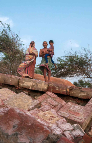

‘If you ever need an essay to be written on how to rebuild houses, let me know,’ said Akhil Maity, a resident of Gobardhanpur village, with a forced smile in a bid to hide his pain. ‘I have rebuilt my house at least 9 to 10 times. Can you see that area on the river? I used to live there once. The water keeps swallowing my house, and we keep receding back.’
The waterbody Akhil pointed at, some 500 meters away, was the Bay of Bengal. Akhil’s village (on G-Plot island, Patharpratima Block) could be said to be the southernmost tip of the world’s largest river delta— the Sundarbans. Apart from Gobardhanpur village, Baliara and Kusumtala villages on Mousuni Island (Namkhana Block), and Bakkhali and Shibpur on Sagar Island, are heavily affected from riverbank erosion and rising sea levels. This riverine marshland is in a constant state of flux. Rivers and rivulets change their courses continuously. Saline water inundate homes and agricultural fields twice every day during the high and low tides. Sudden appearance of sand bars in the midst of river channels or swift erosion of river banks is a natural phenomenon. Data shows the Sundarbans have lost more than 400 square kilometres of land in the last 100 years. Islands like Lohachara and Suparibhanga have totally disappeared from maps. Erosion has reduced Ghoramara Island to a mere 4.43 square kilometres from 8.51 square kilometres. Once home to 40,000 people, Ghoramara has faced mass exodus due to habitat loss. The 2011 census counted only 5,000 odd people still struggling on the island.
The Sunderbans comprises 54 inhabited islands out of total 102 islands on the Indian side. The delta stretches into neighbouring Bangladesh and has been recognised by UNESCO as a World Heritage Site for its outstanding biodiversity and ecological significance for both countries. Although located in a swamp, population density in the Sundarban islands is high. Many small-scale industries operate here. Unscrupulous owners of brick-kilns and bheris (pond for pisciculture) often make holes in embankments to harvest river water in their premises. The river water brings in fish, which help pisciculture, while the alluvial silt provide raw material for the brick kilns, totally free of cost. However, such kind of illegal activities weaken the embankments and ultimately they get breached.
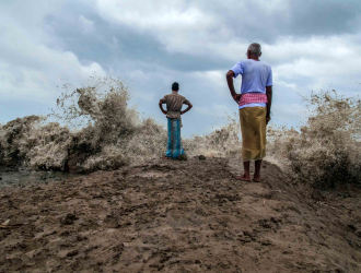
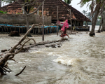
The Sunderbans delta is formed by the River Ganga entering the Bay of Bengal. In this last phase of its journey, the river deposits huge amount of silt on river beds. Long-term silt accumulation has been raising the water level gradually. At present, villages are just about 1.5 to 3 meters above the average sea level. During the full moon or the new moon, when tides can reach five to six meters high, many villages get flooded, and sometimes entire villages have collapsed and sunk without trace. Crude mud embankments form the only protection from the high water level. Though concrete embankments were constructed at some places after Cyclone Aila, they are in very poor condition or still incomplete. The danger of being submerged by rising water levels is all too real for people living here.
‘We used to live by the river. We used to farm our land nearby. The river took everything away. Then we started living at the head of 12 Sowal. After Cyclone Aila (2009), increased riverbank erosion ate up our house. Displaced since then, we came here 7–8 years ago. Until last year, our new house used to get flooded too. Water entered even through the windows. This year we could stop the flooding by increasing the height of the hut. Where shall we go? We need a place to live peacefully with our children,” said Sheikh Sadek, Sheikh Naju, Asma Bibi and others of Baliara village on Mousuni Island.
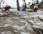
Tropical cyclones have become a recurring feature in the Sundarbans in recent times. Three deadly cyclones hit the Sundarbans in the last decade; each more destructive than the one before. In 2009, Aila made landfall hitting 110 km/hour wind speeds. In November 2019, Bulbul recorded wind speeds as high as 130-135 km/hour. Super cyclone Amphan hit in May 2020, clocking wind speeds of 185 km/hour, highest ever recorded in the state. During Aila, embankments collapsed in more than 100 places, inundating several islands. As a result of increase in salinity in the soil, farmlands have lost soil fertility. Now people can only catch a few fish and crabs or gather sticks from the forest in the once rich cultivable lands. Thousands have lost their lands, homes and jobs, and have become ‘climate refugees’.
Dr Kalyan Rudra, Chairman of West Bengal Pollution Control Board, explains the plight of the Sundarbans in so many words, ‘Water level of the Bay of Bengal is rising faster than other seas. Moreover, the regular coastal subsidence along the Bengal coastline has worsened. The coastal land is subsiding at a rate of 2.9 mm every year. When we combine the two factors of coastal land subsidence and rising of seawater level (3.6 + 2.9), we find that water in the Bay of Bengal (in Bengal basin) is rising by 6.5 mm each year. In short, the sea is advancing rapidly. A 2012 report from the Centre for Science and Environment says that the Bay of Bengal is warming at a rate of 0.500 per decade, while temperature of other seas is rising at a rate of 0.070. This is the reason for increasing number of cyclones occurring in the Bay of Bengal.’
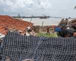
After Cyclone Aila hit in 2009, the West Bengal Government initiated a plan to construct a series of embankments with a low slope angle. The reason for keeping the slope at a low angle was to allow embankments to withstand the immense pressure of water hitting it and the lashing by high-speed winds. The construction of this kind of embankment requires a lot of land. Petty local politics made people unwilling to give up their land for the embankments. As a result, concrete embankments could not be erected at many places. Emergency situations are met by ad hoc measures like raising the height of the embankment or by covering bamboo poles and bamboo fences(darma) with mud. More than 90 per cent of embankments in the Sundarbans are still made of soft alluvial clay.
‘What is the solution?’ I ask Dr Rudra. ‘If we build an embankment after vacating a wide area where the tidal waves are active (the intertidal space), we can live in peace for many years. We have to plant mangrove seedlings in that intertidal space. This will ensure that the mangrove forest bear the brunt of huge waves coming from the sea. It was observed during Aila, Bulbul, and Amphan cyclones that islands having thick mangrove covering were less damaged. As the cyclone hovered over the mangroves for a long time, it weakened the force of the wind as well. Many trees must have got uprooted, but new trees grow on their own in undisturbed jungles. So, it is not that grave a danger. Rather it has been proven again and again that only a mangrove forest can protect local settlements from disasters.’
Sundarban enthusiast Jyotirindranarayan Lahiri asks, ‘Why should the Sundarbans be a slave to destiny? Why should anyone who lives next to one of the most famous forests in the world consider himself unfortunate?’ Jyotindra has experience of running an NGO in the Sundarbans for about a decade. He adds from his own experience, ‘Schools have to impart practical knowledge to students as to how to manage natural disasters (through mock drills), and teach them methods of survival. It is necessary to recognise that people living in the Sundarbans inhabit a disaster-prone zone and take preventive measures accordingly. For example, the recent Amphan cyclone showed that loss of life could be mitigated to a great extent if people took shelter in the Flood Centres during the storm.’
The Sundarbans is a liminal space: a space in transition, neither land nor water. What is created one day is destroyed the other. The Sundarbans is beautiful, but it is also dangerous. One cannot fight against nature every day, but that is what the people living here must do to live, blurring differences of ethnicity and religion in their daily struggle for survival. How many times can a person build his house from scratch? Every year the sea eats up little more land from beneath their feet or a cyclone strikes them from the sky above. This part of India is not part of the economic growth story, but the people of the Sundarbans deserve our immediate attention, because theirs is an epic story of survival against all odds.


, loosely translated as ‘sitting down near’, meaning, the student sitting down near the teacher while receiving spiritual knowledge. This knowledge is passed down through generations of guru–shishyas in an unbroken chain, thus establishing a parampara. This pedagogy, typically Indian in nature and origin, has sustained many intangible heritage and cultural traditions of India. Indian classical dance is one of them.")