
The earliest cities in South Asia were those of the northwestern part of the subcontinent, what we call the Harappan civilization. This was a Bronze Age civilization, a term that refers to communities using bronze as a material to make their major tools, but more importantly implies urban societies. Several early Bronze Age societies in the Old World are known, which include Mesopotamia, Egypt and China, other than the Harappan. The Harappan settlements were younger contemporaries of the Mesopotamian cities, and were distinctly urban. V. Gordon Childe was one of the first to outline criteria for the early city in 1950 (Childe 1950:3-17). These criteria were size of settlement and density of population, occupational specialization, the presence of surplus in the economy, monumental public buildings, a ruling class, systems of recording and exact sciences, writing, art, ‘foreign’ trade and a state organization. These criteria are not necessarily found in every urban context, but it is the linkages that existed between them that are important. The term ‘urbanism’ refers to the state of being urban, while the term ‘urbanisation’ refers to the process of becoming urban.
Harappan sites are located in the northwestern part of the Indian subcontinent, occupying much of present-day Pakistan. In India, Harappan sites are found in Kutch and parts of Saurashtra in Gujarat, and parts of Rajasthan, Haryana, Punjab, and western Uttar Pradesh. What is known as the urban phase of the Harappan period (because there are pre-urban and post-urban phases too) is generally dated from about 2600 to 1900 or 1800 BCE. The urban phase is also called Mature Harappan phase, and is characterized by certain distinctive material traits, such as long chert blades, steatite seals, chert weights, red pottery with black designs, bronze tools of certain types, beads of specific designs and shapes, as well as bricks used for construction made in a particular ratio (Figures 1 and 2) (Ratnagar 2001). These material traits have helped archaeologists label or identify an archaeological site as Harappan.
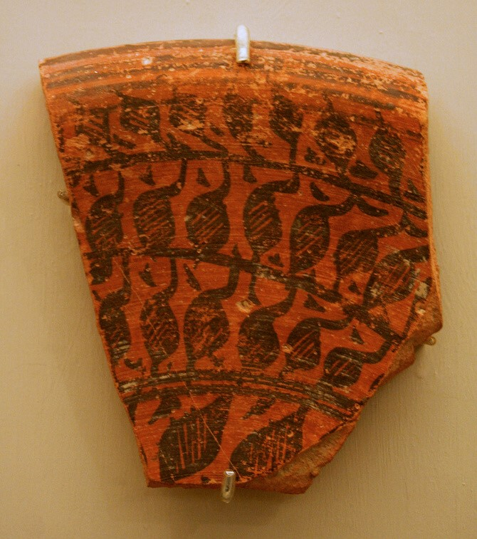
Figure 1: Harappan Red Slipped Pottery with Black Paintings
(Source: Wikimedia Commons)
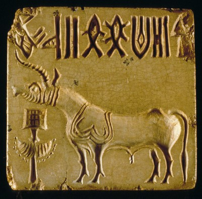
Figure 2: A Harappan ‘Unicorn’ Seal
(Source: Wikimedia Commons)
How we know about the Harappan differentiates it from other early Bronze Age societies. Mesopotamian and Egyptian societies come alive through their written sources in the form of terracotta tablets, inscribed material, and stone inscriptions. Archaeologists studying the Harappan, in contrast, have been completely dependent on material remains of the past. This is because what has been considered as writing, and is found on a number of materials, remains undeciphered till date. Thus, it is material such as tools, ornaments, toys, figurines and statues, as well as houses that tell us how people in the third millennium BCE lived in South Asia. It is these materials, the subject matter of archaeology, that tell us about how ordinary people lived their lives, whereas the written word in Mesopotamia and Egypt informs us about their rulers, religion, and trade. It is possible that when Harappan writing is deciphered, we may get to know what language they spoke or what were their beliefs. Harappan inscribed material that survives is also much less than what was generated by their counterparts in Mesopotamia and Egypt and it is tempting to think that other organic materials may have been used for writing in South Asia. Recently, some scholars have suggested that the signs found on Harappan objects were not in fact ‘writing’, a theory that is, however, not widely accepted.
How did urbanism originate in the Greater Indus Valley? Archaeologists have long known of settlements or occupations that were earlier to the Harappan cities that have been variously called Early Harappan, pre-Harappan or Early Indus, dated from about 3500–2600 BCE. Archaeologists call these as ‘cultures’, which are seen purely in terms of material. In this period, there were four such cultures, called Amri/Nal, Kot Diji, Sothi/Siswal and Damb Sadaat. These differ from each other in terms of geography and materially in terms of pottery. Most of the distinctive features of the Harappan civilization were entirely absent. Not only this, monumental architecture, a feature of urban spaces, is not part of Early Harappan settlements. These also seem to be more local societies with locally available materials being utilized. What was, however, common between the Early and Mature Harappan was the basic subsistence base (of wheat, barley, sesame, linseed, dates, sheep, goat and cattle), the use of brick for construction, the cart for transportation, the use of terracotta cakes and terracotta and stone missiles, as well as a few designs on pottery.
Changes in settlement histories in many cases, mark the shift to the Mature Harappan. For example, out of a total of 52 Early Harappan sites in Sind, 29 were abandoned. The picture is far more stark in the case of the Cholistan, where out of 37 Early Harappan sites, as many as 33 were abandoned, and out of 136 Mature Harappan sites, 132 were set up in new locations. Recent surveys in the Upper Indus region by Rita Wright have also shown that all the seven pre-urban settlements along the Chenab and four out of nine along the Ravi River were abandoned in the Mature Harappan period (Wright 2010). There, thus, seems to be a preference for new locations in the Mature Harappan period, or a rejection of the older settlements. We should not see the transition as the replacement of Early Harappan by the Mature Harappan. At the same time, no single Early Harappan culture can be seen as the progenitor of the Mature Harappan. Moreover, the Early and Mature Harappan did co-exist, as at Rahman Dheri in the northern Punjab, where from 2500 to 1900 BCE, the material culture remained Kot Dijian. If we put these disjunctures between the Early and Mature Harappan together with the absence of elements indicative of urbanism, we would have to suggest a rapid onset of urban growth in the Indus Valley.
One of the most distinctive features of Harappan cities is that they were divided. This division could result from separating and walling off parts of the settlement from others, or sometimes by internally building walls in a compact settlement. Both seem to be deliberate attempts to separate either functions or people or both. Mohenjodaro provides the clearest evidence of a divided settlement of the former kind (Figure 3). There are distinctly two mounds, one, a smaller (about eight hectares) and higher one to the west and the other, a larger (about 115 hectares) and less elevated one to the east, both separated by an area of about 150 meters. These were termed as ‘Citadel’ and ‘Lower Town’ respectively.
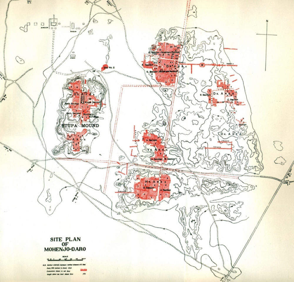
Figure 3: The Two Mounds at Mohenjodaro. Excavated Areas are shown in red
(Source: Mackay 1937)
Most Harappan settlements were walled. Many of these walls were massive: those at Dholavira were 18 meters wide and at least nine meters high. Even a small settlement with a size of 1.92 hectares such as the recently excavated Bagasra (Gola Dhoro), in Kutch district of Gujarat, had a wall around it with a width of 5.20 meters. Walls were free-standing or built as supports for baked brick platforms. Walls around a settlement can, however, have diverse functions and are not only defensive in nature. Walls protected settlements from natural forces (such as floods), as well as reinforced platforms and worked as exclusionary devices. Whatever their function, walls clearly controlled access into and out of the city.
Excavations at Mohenjodaro detected massive platforms on both the Citadel and Lower Town that were ostensibly built for flood protection. These platforms on the Citadel were more than six meters high and on these the various buildings were constructed. At Harappa, masses of sun-dried brick comprised similar platforms to protect the city from floods. Both categories of architecture, walls and platforms, as also the use of burnt brick for structures, illustrate the extensive utilization of labour in the ancient cities. On the assumption that a labourer can move about a cubic meter of earth in a day, Gregory Possehl suggested that the Mohenjodaro platforms would have taken about four million days of labour to construct. That would mean 10,000 labourers working 400 days or a little over a year. 2,500 labourers would have taken 1,600 days or four years and four months ‘just to put the "foundations" in place (Possehl 2002). ’
An important implication of the foundations or platforms is that they would have formed part of a plan for a Harappan city before it was built. Planning of Harappan cities can be physically investigated through the roads and streets, the intersections of which comprise the so-called grid plan. At Mohenjodaro, the north–south roads (First and Second Streets) are clearer than the east–west ones (Figure 4). Possehl writes that the layout is regular but not perfect. ‘The regularity itself suggests that the founders of this city started with a clean plate, virgin soil, on which they began the construction of their metropolis.’
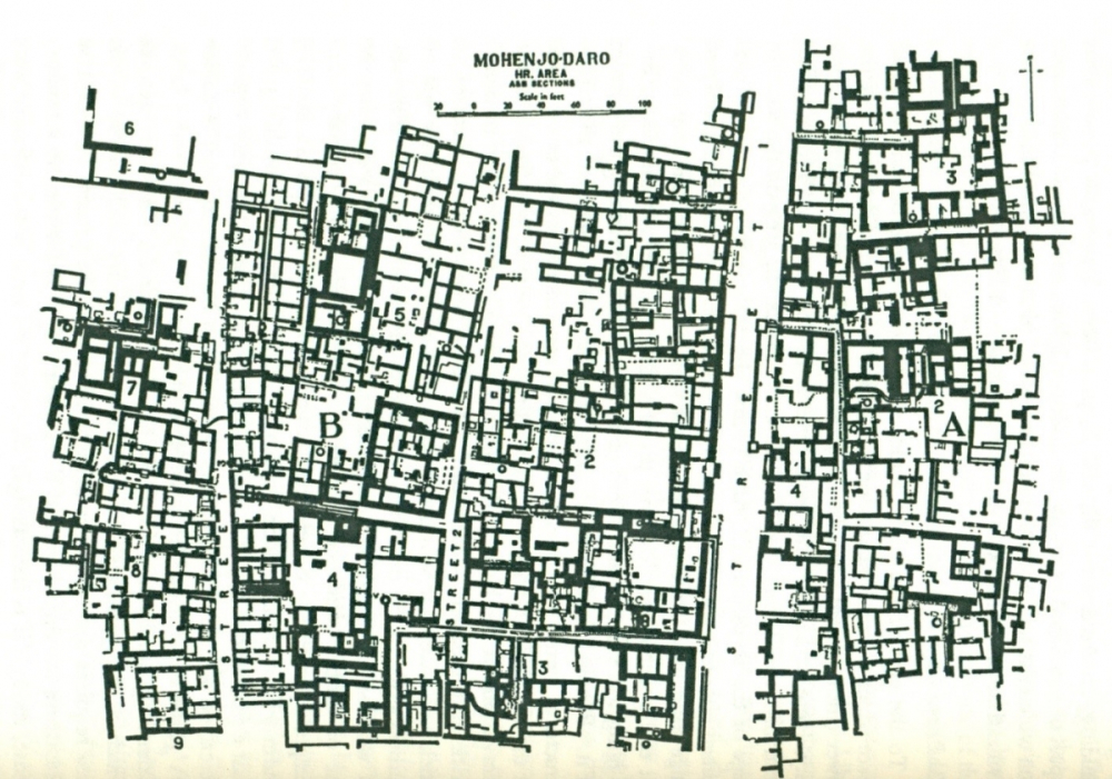
Figure 4: Streets and Lanes in HR Area, Mohenjodaro
(Source: Marshall 1931)
Other indications of planning can be seen in the provision of civic facilities, such as the extensive system of burnt brick drains that ran along the main avenues of a city connecting public drains with house facilities (Figure 5). Within individual houses, drains were of both horizontal and vertical types, the latter being pipes in the walls. The location of every single house had to be planned to have at least one wall along a lane or street so as to access the street drains. The provision of sullage pits and manholes, into which solid waste would collect and which would have had to be regularly cleaned, was an important feature of the system. Such drains can be seen at numerous other sites, such as Harappa, Kalibangan, Nausharo, Chanhudaro, Allahadino, Dholavira and Lothal. At sites such as Lothal, where the architecture was mainly of mud-brick, the drains were of baked brick. Evidence of the consciousness to provide civic amenities were also revealed by garbage dumps, one of which was found north of the city of Mohenjodaro.
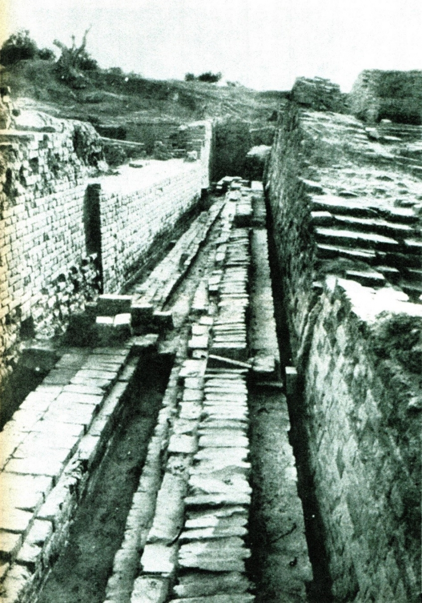
Figure 5: A Mohenjodaro Lane with Covered Drains
(Source: Wheeler 1968)
Wells for drinking water are noted at Mohenjodaro and Harappa. On the basis of the distribution of excavated wells at Mohenjodaro, Michael Jansen calculated that about 700 wells probably existed at the site in antiquity (Jansen 1989:247–256). These varied in size, with an average diameter of one metre, and most were located within individual houses. However, wells were often found near entrances, implying that they were accessible to outsiders. At Harappa, the six wells recovered during excavations were all located in public areas. The high density of wells at Mohenjodaro suggests that the mean distance between wells was quite low. In the Lower Town, the mean distance between wells ranged from 36 to 39 metres, which may also imply that their locations were planned at the outset.
Another aspect of planning in architecture can be seen in the use of bricks with a ratio of 1:2:4. Thus, at Mohenjodaro the common size for bricks was 28 x 14 x 7 cm, which were mainly of burnt bricks, while at other sites mud-bricks in the same ratios were used in construction. Uniformly sized bricks enabled ease of construction. Walls were generally constructed using a bonding technique known as ‘English bond’ where bricks were laid in alternate headers and stretchers. Usually mud mortar was used to bind bricks together while very rarely the use of mud and gypsum or lime and gypsum are noticed.

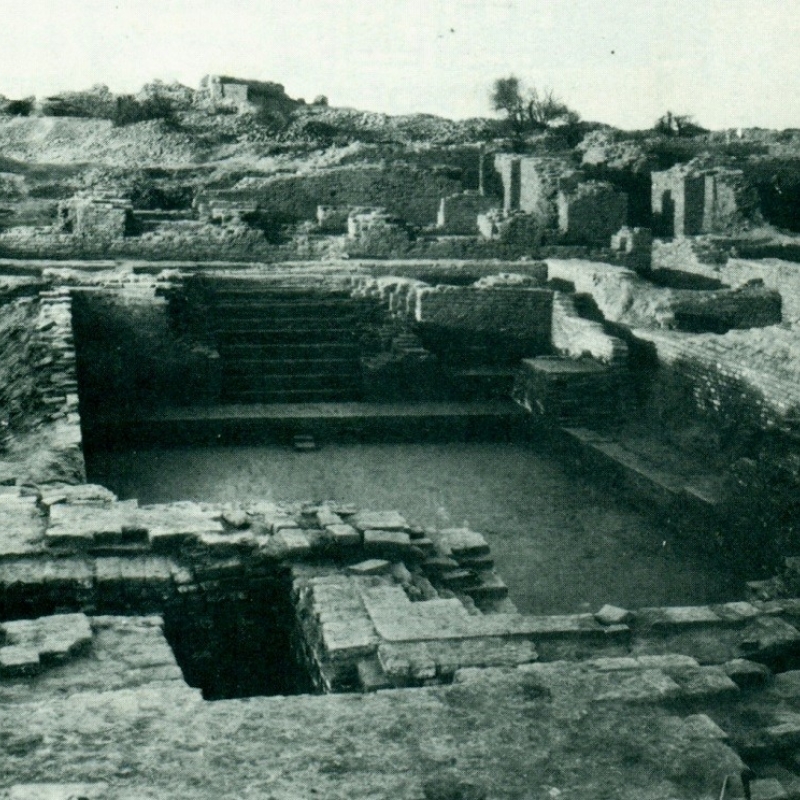
Figure 6: The Great Bath at Mohenjodaro
(Source: Wheeler 1968)
Specialised architecture (Gordon Childe’s large monumental architecture) gives important evidence for differentiated functions in an urban context. Structures such as the Great Bath at Mohenjodaro (Figure 6), the granary and the workmen’s quarters with circular platforms and furnaces at Harappa, are clearly loci of specialized functions. These are found on the respective ‘citadel’ mounds at both sites. But there are certain ambiguous structures found in the ‘lower town’: for example, House 1 in Section HR-A[1] of Mohenjodaro has been suggested to have been a temple on account of its size, its means of access through two monumental stairways, the ‘tree-guard’ in the courtyard, as well as finds of stone statuary within and in the vicinity of the structure. Similarly, in the northern part of Mohenjodaro, in the DK-G[2] area, a large building termed as a ‘palace’ was uncovered. This alerts us to the possibility that many of the large structures may have had specialised functions. Yet, apart from size, there is often little material within the buildings to indicate their non-residential use.
What were these specialized public functions taking place on the ‘citadels’? These seem to have ranged from large-scale storage facilities to places of assembly and ritual. There seem also to have been living arrangements for a very small section of society, perhaps ritual practitioners. On the southern half of the ‘citadel’ at Kalibangan were found a series of mud-brick platforms with oval pits lined with mud plaster or bricks that have been considered as ritual in nature and have been termed as ‘fire altars’. At Rakhigarhi, too, a row of fire altars has been found on a podium or platform on the Citadel. Similarly, the ‘Acropolis’ at Lothal, too, has fire altars located on it.
Public space was also taken up by the roads and streets that passed through various settlements. These were arteries in many cases, allowing access between different parts of the city. This is very clear at Mohenjodaro where the different excavated localities, such as HR or VS[3] or DK, were in fact connected through the roads and streets. These roads and streets were also important for providing avenues for the public drains. At Lothal, streets and lanes in the citadel (called the Acropolis) were paved with mud bricks and covered with a layer of limestone (kanker), while those in the lower town had a base of terracotta balls or kanker.
Cemeteries discovered at Harappa, Kalibangan, Lothal, Ropar and Rakhigarhi comprise non-domestic use of space. However, no cemetery has yet been found at a major settlement such as Mohenjodaro. An implication in the practice of cemeteries involves the keeping aside of space for burials, important particularly in an urban situation, because space would have been at a premium within a city. At Harappa, the cemetery labelled R 37 is located about 250 m to the south of the high mound AB, while at Kalibangan the cemetery lay about 300 metres west-south-west of the habitation. Just like these two sites, the cemetery at Lothal too lay outside the walls but about 10 m away and due west of the settlement. At all these three sites, the cemeteries were situated outside the walled areas demarcating the living spaces. The significance of these burial spaces lay in the clear demarcation between the living and the dead. At the same time it can be seen that it was necessary to allot space outside the settlement, yet not too far away, for the dead.
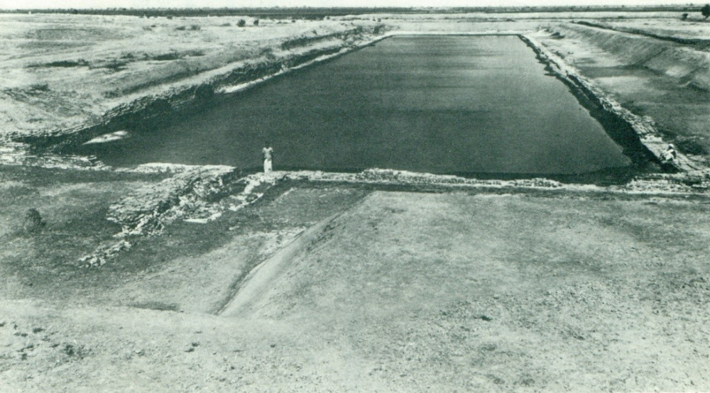
Figure 7: The ‘Dockyard’ at Lothal
(Source: Rao 1979)
Public space was used in a strikingly different manner at Dholavira, in Kutch. Here, several massive reservoirs or water storage tanks were constructed along the inner side of the outer wall. In one case, one of the reservoirs was cut into the bedrock while in another case stone blocks were used in construction. Flights of steps provided access into the reservoirs, which were probably excavated for the storage of rainwater. At Lothal, a large brick-built tank which held water can be seen immediately to the east of the settlement (Figure 7). This has been called a ‘dockyard’ suggesting that small boats could reach the site from the Gulf of Khambhat through the nearby river. Yet another enclosure for water, the Great Bath, was constructed at Mohenjodaro, in this case perhaps for ritual purposes.
At Dholavira, another kind of public space has been noted to the north of the Citadel (or between the Citadel and the Lower Town). This is an area of about 100 x 275 metres and has been interpreted by the excavator as a ‘ceremonial ground’ or ‘stadium’ or an area for ‘holding bazaars’. Except for the Lower Town, which is built upto the outer wall, there are also considerable open areas to the north and the south (between the Citadel and the outer wall and the ‘Middle Town’ and the outer wall).
There is plenty of evidence for the domestic use of space, with houses having been recovered at practically every excavated Harappan site. The considerable variety in house forms within as well as between sites is particularly interesting. Numerous houses at Mohenjodaro were built using the courtyard as an open space generally surrounded by other rooms. Open spaces may also have been used to separate individual structures or house units as seen from several parts of Mohenjodaro. Houses at Mohenjodaro were studied by Michael Jansen looking at the placement of their rooms and their means of access. Thus, entrance rooms were distinguished from transit and terminal rooms. Transit rooms were those with more than one entrance. Terminal rooms were those such as the toilet and bath and had only one entrance (Jansen 1984:39–62). Classifications on the basis of this kind of access system enabled labelling of rooms as public and private. In many houses, a second storey could be accessed from one or two sets of stairways, which were always within the house. Most houses had at least one paved room functioning as a bathing area, from where drains connected with the street drains.
Both Harappa and Mohenjodaro, however, were marked by the use of baked brick for housing and public architecture. But at other settlements, construction was undertaken in what may have been locally available materials such as stone, as at Surkotada. Floors were sometimes paved with mud-bricks and in other cases made of rammed earth or lime and kanker. Holes in the ground, called as postholes, suggest that posts or poles were embedded in them and used as supports for the roofs which may have been of bamboo or wood. We do not know whether walls were decorated with paint, but they were definitely plastered with lime. Sometimes, walls of rooms had several niches all along their length perhaps for keeping things. At cities like Mohenjodaro, large rooms would have been left open or unroofed (such as courtyards), as this would have required large wooden beams, or perhaps supported mid-way across the room with wooden pillars. Much of the light in these houses, in fact, would have come from the open courtyard as outer walls of houses had few windows, which were usually very small.
An interesting feature at Mohenjodaro is the sharing of walls by individual houses. Thus, the western wall of one house may be the eastern wall of the adjacent one. Houses, thus, form blocks that may have been closely intertwined in more than just physical ways. There would have been interaction among and negotiations between these closely spaced houses, for the repair of one house would have affected its neighbours.
Archaeology throws light on how people lived, what they ate, what they did for a living, what they wore, and other aspects of their everyday lives. Archaeologists recover burnt seeds that tell us what crops they grew and what cereals and pulses they ate. Bones of animals tell us these were part of the diet too. Some of these bones are of wild animals that may indicate hunting practices. Fish bones have been recovered in excavations showing that river and also sea fish were part of the diet. Harappan agriculture provided a well-rounded range of crops with varied cereals, oil and fibre crops. Combined with animal protein, it showed that the Harappan diet was a varied one. Agriculture was also intensive in that the same fields were used for growing more than a single annual crop. The evidence for both winter and summer crops meant the Harappans practiced double cropping. Though plough shares have not been recovered yet, terracotta toy models of ploughs indicate that they were used.
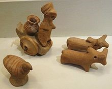
Figure 8: Harappan terracotta animal and human figurines
(Source: Wikimedia Commons)
Other toy models are also interesting because they give us vignettes of the lives of Harappan people, and tell us what they were familiar with. A range of terracotta animal figurines were made that may have been toys (Figure 8). Among these, bulls are common, as also the ram and the dog. We assume that bullocks would have been used for ploughing and for transportation. Terracotta and human figurines tell us about the craft of working with clay. Pottery is one of the most important ways by which archaeologists identify Harappan sites, and are able to distinguish Harappan from Early Indus and Late Harappan settlements. Pottery is also one of the largest bodies of material that is recovered from an archaeological site and seems to have been a significant craft given the amount of terracotta vessels that would have been required. This was simply because pots were so commonly used, for everyday functions (storing, cooking, serving, and carrying) as well as for special purposes (such as rituals).
That ordinary material, clay, was the most commonly available material in alluvial zones, and it is no surprise that a varied range of objects for routine purposes was made from clay. Apart from the figurines and pottery mentioned above, there were also varied ornaments (bangles, rings, beads, amulets); spindle whorls for weaving; and flesh rubbers. Stone, less commonly found, was used for making myriad objects, ranging from blades, ornaments, utensils, weights, seals to sling balls and statues. Even more rare were copper and bronze, yet these were fashioned into tools, utensils, amulets, ornaments, and figurines.
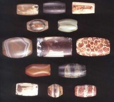
Figure 9: Harappan beads: an etched bead at the extreme right in the middle row
(Source: Wikimedia Commons)
Some of the most exceptional archaeological work has been done in Harappan crafts and purely through recovery, as well as visual and scientific examination of material. Harappan crafters were versatile in transforming materials such as carnelian by etching them (Figure 9), bleaching grey and yellow steatites into brilliant white, and had mastered the art of miniaturizing. Considerable skill was employed in reworking materials into new forms, such as steatite powder into a type of faience specific to the Harappans, or making minute steatite disc beads. The rarity of many of these artefacts indicates their value and makes them highly identifiable. Thus, we know that some of these artefacts, such as etched carnelian beads, were also carried to distant regions such as Mesopotamia.
Excavations have shown that craft production was not practised at every Harappan settlement. Yet, we find distinctive Harappan artefacts at every settlement, small and large. It is also likely that foodgrains may have been transported to large cities to meet their requirements. We can imagine a scenario where the exchange of goods over land and water would have brought people from rural settlements, pastoral camps and urban spaces together. The mechanisms for this bustling exchange can be seen materially through objects like terracotta toycarts (Figure 10) and artistic depictions of river boats.
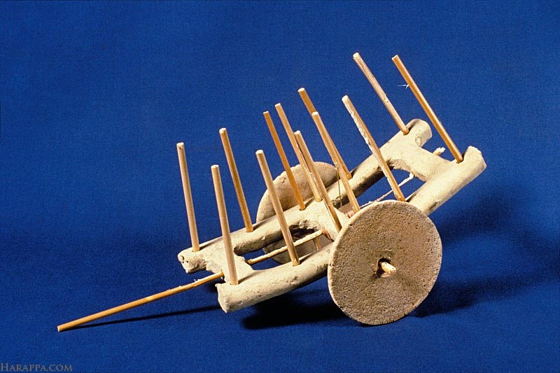
Figure 10: A Harappan Toycart
(Source: Wikimedia Commons)
The finding of Harappan material in distant lands was one of the first pointers towards a Bronze Age date for the Harappan civilization. Archaeologists now know, through material evidence, of Harappan contact with ancient Oman and Bahrain, as well as with Kashmir and Karnataka within the Indian subcontinent. For the Harappan civilization localized to the northwestern part of the subcontinent, contacts with other areas of the subcontinent seem to have been primarily for raw materials, possibly wood and gold.
Many of the raw material resource areas were outside the Harappan occupied zone, and this would have meant contact with local communities. Copper, for example, was possibly mined in the Khetri region, an area where there are no Harappan sites. However, there was a local copper-using archaeological culture called by archaeologists the Ganeshwar-Jodhpura culture. Thus, either the Harappans travelled to these areas to mine, smelt and transport back ingots to Harappan sites or engaged in exchanges with these local communities at a possible intermediate location. With certain other materials like shell, we find that the Harappans established settlements (such as Nageshwar and Balakot) to obtain the raw material, whereas in other cases like steatite (south Rajasthan) or carnelian (south Gujarat) or even hard woods (south Gujarat and the Himalayan foothills), these may have been obtained through Harappan expeditions. It must be similar forays into southern India, perhaps to obtain gold, which resulted in micro steatite beads being found at Neolithic sites in Karnataka. Sumerian texts refer to expeditions that brought back required raw materials, particularly for temples and elite purposes, and it is a pity that no such literature survives in the Harappan case.
It is likely that the Harappans travelled to Oman, perhaps for copper. We find pieces of a distinctive type of Harappan vessel, a tall black slipped jar at Omani sites that suggest that what was carried towards Oman may have been something contained in these jars. Evidence of Harappan contact with Oman comes from Mesopotamian literature, which tells us of materials coming from three regions called Dilmun, Magan and Meluhha. These have been identified respectively as Bahrain, Oman and the Harappan region. These texts inform us that objects that can be called luxuries were taken from the Harappan region towards Mesopotamia. However, very few Mesopotamian materials are found at Harappan sites, suggesting that what was carried may have been perishable in nature. Contact between the Harappan region and Bahrain is clearly indicated by the weight system followed in the island, which follows the Harappan weighing standard. The Mesopotamian texts corroborate what is known from archaeology: that the Bronze Age world was an open one with people, materials and goods moving freely across space.
Two distinctive Harappan artefacts are hugely useful as they tell us about the exchanges carried out by the Harappans. These are the cubical chert weights and the steatite seals. All Harappan weights follow a uniform standard over the entire region. These weights also were produced at very few Harappan settlements, suggesting they were produced under supervision. These are largely made from a good quality chert, coming from a single source in the Rohri Hills of Sind, a source that also supplied the stone for the long blades, another distinctive Harappan object.
Harappan seals are a significant category of artefact from multiple points of view. These seals were made out of steatite which was then fired to achieve a white surface. The back of the seal had a projection with a hole in it, which meant that the owner threaded the seal on a string, and perhaps wore it around the neck. Unlike Mesopotamian seals which were cylindrical in shape and had to be rolled over a clay surface to make the design, the Harappan seal was a stamp seal which was impressed on wet clay to get the design. We can see these seals as artistic products, testifying to an engraving skill perhaps not available to all. Most of the seals have two or three elements: one, an animal motif; two, a line of sign-like emblems; and three, sometimes an object (often on a stand, or looks like a box) that is carved under the animal’s head (Figure 11). The sign-like symbols have caught the attention of scholars as these have been identified as writing. If these were writing, they indicate a level of literacy achieved by the crafters making the seals. Apart from animal motifs, there are also seals that show narrative scenes that seem to indicate actions and episodes that may have had some ritual content.
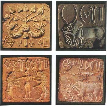
Figure 11: Harappan Seals
(Source: Wikimedia Commons)
Harappan seals were used to convey a message and this came through the inscriptions as well as the motif. The message probably pertained to the identity of the sender. Thus, what would reach the receiver would be the package with the clay tag or sealing which would identify the sender. If the sealing was intact, it meant the package had not been tampered with. The fact that the motif and signs were in relief meant the object was to be stamped on another material such as clay. This has been proved by several clay pieces bearing seal impressions which were hence called sealings. Seals and sealings comprise an important part of exchange transactions.
So, what do we know of the Harappan world? At a settlement like Mohenjodaro, each area that we now know as HR, or VS, or DK-G, was a world in itself, each being circumscribed by walls. And within this world, the lanes and streets divided groups of houses into blocks that were separated from other blocks. Yet, there are public spaces that would have been used by the inhabitants of the settlement. At Mohenjodaro, many of these public spaces lie within the blocks. At other settlements, common resources for water or for burying the dead would have brought the community together.
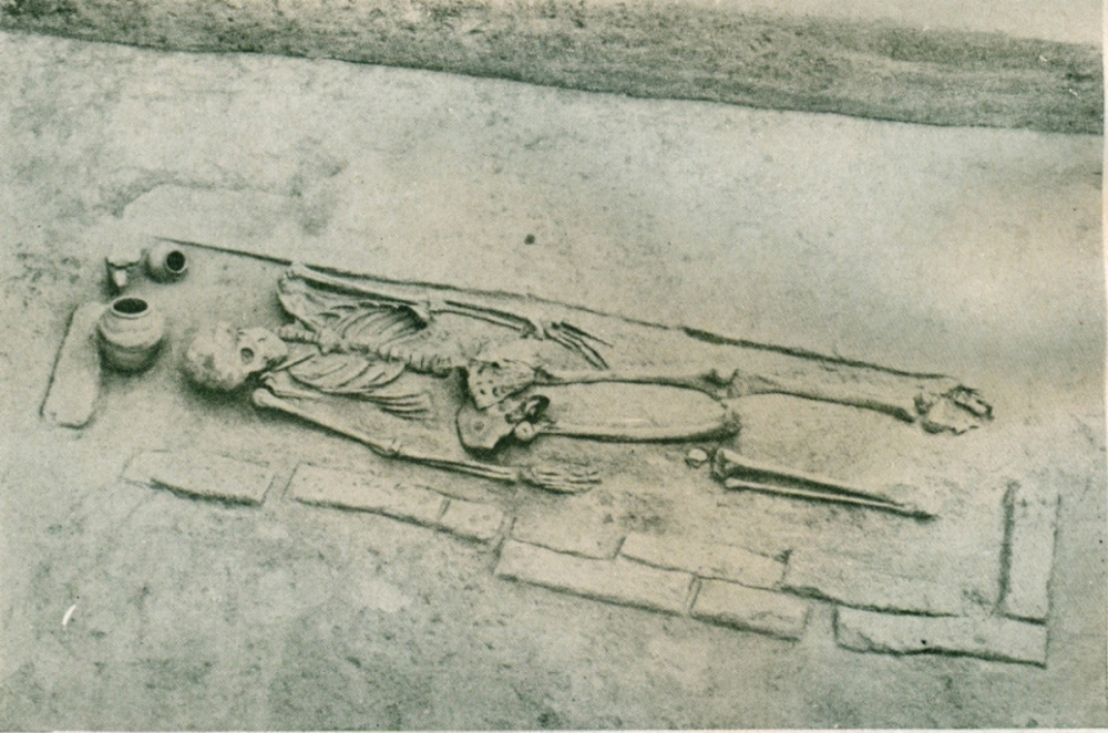
Figure 12: A Mud-Brick Lined Burial with a Few Pots from Harappa
(Source: Wheeler 1947, Plate XXXVII B)
Since we have no texts for this period, material evidence can help us in understanding Harappan society. Harappan beliefs in an afterlife seem to be indicated by burials within cemeteries that we find at a few settlements. Most bodies were laid out lengthwise in pits with a few pots usually arranged near the head and also near the feet and sometimes under the body (Figure 12). The grave pit was usually wider near the head due to the majority of pots kept there. At Harappa, pots varied from two to 40 with an average of 15-20. Occasionally, brick-lined pits or wooden coffins were used for the bodies. Personal ornaments are sometimes found with the bodies but there are hardly any other objects that were interred along with the dead. Pendants and beads of carnelian, lapis and copper found near the pelvis or lower back of skeletons of men and women are suggested to have been amuletic in nature, being worn next to the skin under their clothing. In a few cases, bronze mirrors have been found with female bodies. The major item found in graves was, however, pottery, in quantities varying from none to 40 per grave. What is interesting is that some ceramic types were not found in the habitation areas and, thus, these may have been made only for burials. At Kalibangan, there are two other types of burial, neither of which have any skeletal remains: one, pot burials, and the other, pits with vessels. Both these types appear to be symbolic in nature due to the absence of bodies. The contrast between Harappan burials and those in other Bronze Age contexts lies in the relative uniformity in the former. The only marked difference between Harappan burials lies in the quantities of vessels found in individual burials. Unlike Mesopotamia or Egypt, it appears as if the Harappans did not believe in putting wealth out of circulation by burying them with the dead.
The urban Harappan period lasted for roughly 700 years. Those 700 years would have seen periods of intermittent upheaval as suggested by the periodic floods that ravaged Mohenjodaro. After 1900 BCE, however, most of the major cities of the Harappan civilization were abandoned or were clearly in stress. It is difficult for archaeologists to point to environmental degradation, or floods or earthquakes, as reasons for decline of the Harappan cities, as these factors would affect a sub-region rather than the entire Harappan region. Nor is it the case that the entire area was depopulated or abandoned; in fact, after 1900 BCE, we find settlements with a material culture different from the Mature Harappan, but with some continuities in ceramic forms, terracotta cakes and the use of faience to make ornaments. There also seems to be a sort of reversal to the situation prior to the advent of the Harappan cities, with villages having regional affiliations. Four so-called Late Harappan cultures are now apparent: the Jhukar in southern Sind, Cemetery H in the Cholistan and the southern Punjab, late Siswal in the Sutlej-Yamuna Divide and Rangpur IIB-C in Gujarat and Kathiawar, roughly dated from around 1900–1500 BCE. All these archaeological cultures are distinguished from each other on the basis of their pottery types and designs, and a few artefacts. But, the majority of features that marked Harappan urbanism (such as writing or the use of weights and seals, or adherence to planning in the cities, or to a rich and vibrant material culture) seem to disappear. At the large centres, like Mohenjodaro, the collapse of municipal functions and rules can be seen in houses and kilns intruding onto the streets and being built in public spaces. Thus, it appears that the urban ethos could not be sustained, leading to the disappearance of the Harappan cities.
[1] This refers to A Section of HR Area, the latter which was named after its excavator, H. Hargreaves.
[2] This refers to G Section of DK Area, the latter which was named after its excavator, K.N. Dikshit.
[3] This refers to the area excavated by M.S. Vats.
References
Childe, V.G. 1950. ‘The Urban Revolution’, The Town Planning Review 21.1:3–17.
Jansen, M. 1984. ‘Theoretical aspects of structural analyses for Mohenjo-Daro’, in Reports on Field Work Carried out at Mohenjo-Daro. Interim Reports Vol. I, eds. M. Jansen and G. Urban, pp. 39–62. Aachen and Rome: RWTH and Istituto Italiano per il Medio ed Estremo Oriente.
———1989. ‘Some problems regarding the forma Urbis Mohenjo-Daro’, in South Asian Archaeology 1985, eds. K. Frifelt and P. Sorensen, pp. 247–56. London: Curzon Press.
Mackay, E.J.H. 1937. Further Excavations at Mohenjodaro, vol. 2. Delhi: Archaeological Survey of India.
Marshall, John. 1931. Mohenjodaro and the Indus Civilization, vol. 3. London: Arthur Probsthain.
Possehl, G.L. 2002. The Indus Civilization: A Contemporary Perspective. New Delhi: Vistaar Publications.
Rao, S.R. 1979. Lothal A Harappan Port Town (1955–62), vol. 1 Plate XCVII. New Delhi: Archaeological Survey of India.
Ratnagar, S. 2001. Understanding Harappa Civilization in the Greater Indus Valley. New Delhi: Tulika Books.
Wheeler, Mortimer. 1947. Harappa 1946: The Defences and Cemetery R 37, Ancient India 3:58–130.
———. 1968. The Indus Civilization. Cambridge: Cambridge University Press.
Wright, R. 2010. The Ancient Indus: Urbanism, Economy, and Society. Cambridge: Cambridge University Press.