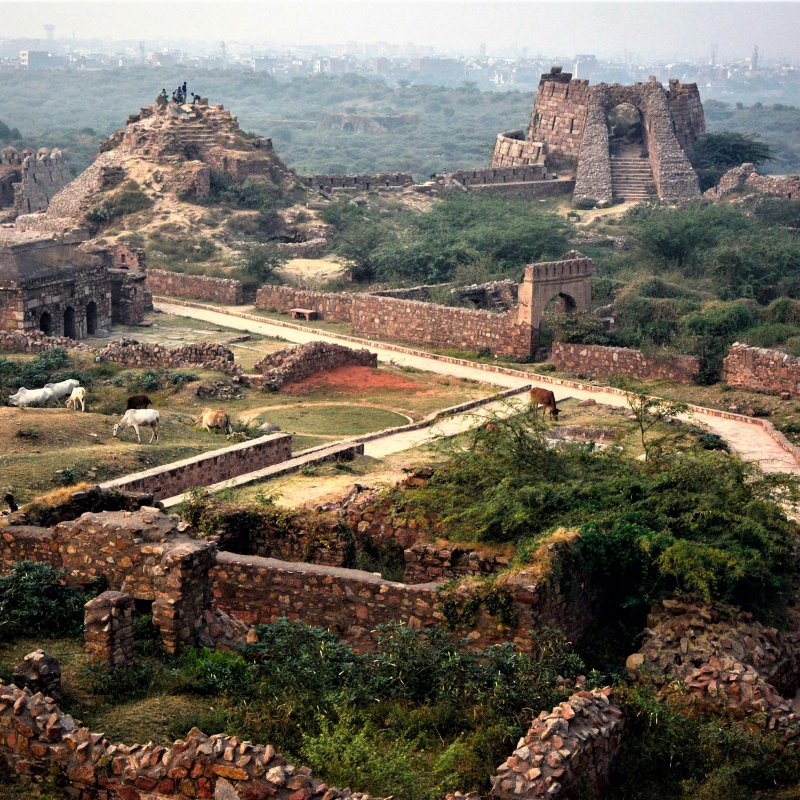
In southern Delhi, on the Badarpur–Mehrauli Road, to the north of Asola greens and Dr Karni Singh Shooting range, rise the ruins of the Tughlaqabad fort. The site still affords a glimpse of a pre-gunpowder era medieval fort and the city it enclosed, since it is still modestly well preserved.
It was built on a local high ground on a terrain that slopes gently from west to east. It is surmised that a small stream (which may not have run throughout the year) ran from west to east passing to the immediate south of this high ground, and to the north of storm-water drains flowing eastwards. This made the approach to this relatively high ground from south and north somewhat difficult. In addition, there were low hills at a short distance to its south. This terrain made it possible to build a dam, stretching from this local height to the hills to its south, to trap the waters of the stream flowing from west to east and convert it into a lake. Even if the lake shrank into a shallow marsh in summer, it represented an obstacle from south to this local high ground. It was this aspect that caught the eye of Tughlaq, who was then charged with defending the boundary of Sultanate of Delhi at Multan-Dipalpur from the Mongol raiders.
There is a saying that Ghiyas-ud-din Tughlaq advised his Sultan, Mubarak Khalji to build a fortified city on this spot. Building a medieval city was a costly proposition and Mubarak Khalji did not want to do so. He is said to have jokingly replied to Tughlaq to build a fort when he (Tughlaq) were to become the sultan. Tughlaq did become the sultan towards the end of 1320 CE and he did build a fortified city at the spot known as Tughlaqabad.
It is possible that he first built a fortification, today known as Nai Ka Kot to the east of Tughlaqabad as a defensive screen. This is because the river Yamuna flows to the east and it, as well as its environs, could have been a transport route along which an army could traverse. Indeed, to the north of Tughlaqabad upstream along the Yamuna lay the settlement of Inderpat (or Indpat) which is consistent with the idea that the plain adjacent to the Yamuna could have been a transport route.
Having secured his eastern flank, Ghiyas-ud-din Tughlaq would have been free to start the construction of his fort. It would have started with the building of bunds (dams) across the path of the stream and other storm-water drains that flowed eastwards. After the monsoon of 1321, an idea would have been obtained about the maximum water levels of the resulting lake. Since the amount of rains can vary from monsoon to monsoon, overages would have been built into the calculations to provide for years of overabundant rainfall. This exercise would have shown that part of the high ground which would have been above the water on which the fort could be built. It was after the monsoon of 1321 that the construction of the fort would have begun in earnest. It seems that there were areas south of the high ground that were above the water line. One of these, probably a pentangular outcrop, was less than 200 metres from the high ground. If an enemy were to get a lodgement here, it would prejudice the security of a fort built on the high ground. To prevent that, a subsidiary pentangular fortification was built here connected to the main fortification by a causeway. Later, he was buried in a red sandstone tomb with a marble dome inside this pentangular fortification.
The fort would have been constructed to an extent that it could be occupied by 1323 or 1324. The walls were made of locally available sandstone and quartzite rubble bonded with limestone mortar. It was then provided a veneer of dressed quartzite. There is evidence that some of it also had a facing of limestone plaster. It is possible that all the labour that could be available may have been pressed into service. There is a popular oral legend tradition associated with the Sufi saint Nizam-al-Din or Nizamuddin, who at the same time was trying to build a baoli (stepwell) for his khanqah (building or space for Sufi gatherings). It is said that he could not find labour for this purpose because they had all been requisitioned to build the fort. As a result workers are said to have worked by the day on the fort at night for the khanqah. At night they required light, so the water of the baoli turned into oil to light the lamps that the workers used. Given the distance of the fort from Nizam-al-Din’s khanqah and the fatigue of the workers after their labours on the fort, the story is unlikely, even if shorn of its miraculous content, but it is consistent with the hypothesis that labour had been pressed into constructing the fort in large numbers.
As a pre-gunpowder era fort, it was defended by high walls with the the walls getting progressively higher from the city defences to the defences of the functional palace area with the highest and strongest walls defending the citadel. The fortification consisted of straight sections called curtains with semi-circular bastions jutting out at intervals designed to enfilade any attacker and provide better observation points. The walls needed to be stronger at the base than at the top and yet be plumb straight from the interior. To provide for such walls, the exterior is sloped or has a batter. To economise on the material and yet provide for strength, the exterior base of the walls has been built against the sloping base of the high ground.
The fort was occupied before it could be fully constructed but was vacated or abandoned either after 1327 or 1329 but definitely by 1334. Once again, there is a tradition relating to this. The Sufi saint Nizam-al-Din is said to have pronounced a curse on this fort with the words ‘Ya base Gujjar ya rahe ujaad’. This translates to ‘either the fort will be occupied by Gujjar’s (a cattle tending tribe) or it will be empty’. Today, the village in the fort has a strong Gujjar element.
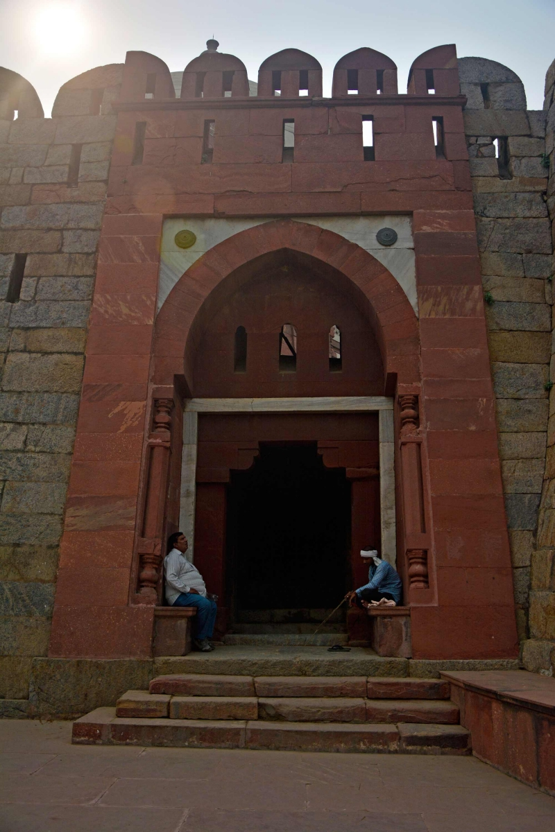
The main fortification has three parts. The largest and the least well defended is the city which has an irregular trapezium shape, with the shorter side to the north and the longer side to the south which was protected by the lake cum marsh. The second and third parts of the fortification are located at the western part of the southern side of this trapezium. These two parts are defended from the city itself by a higher fortification wall with a defensive ditch in front of it. These two parts probably formed a functional palace area and the citadel, respectively. The functional palace area, which lies in the extreme south western part of the fort is somewhat rectangular in shape, with the east–west length being much greater than the north–south length. Its walls face outwards to its west and south (where it faced the lake). To its north it faces the city. It had four gates opening on the west, south, east and north. Of these, the west and the south gates open out of the fort, while the north and the east gates open into the city. The south gate opened on to the lake, which was considered by its planners to be a good obstacle. Hence it does not have an outwork protecting it. Even so, it has the characteristics of a fort entrance. It is placed between two flanking bastions and provides for no straight entry, in the sense, that the way in turns at right angles to the left. The passageway of entrance is flanked by the guard rooms. In this way entry is made difficult for anybody of soldiers who seek to force an entry. This gate has been restored to some extent by the Archaeological Survey of India (ASI). One of the bastions on the southern wall, to the east of the south gate, is not semi-circular but square in shape. This was probably made so in order to accommodate an engine of war. Presumably there was a spit of land nearby, which may have been above the water level when the levels of the lake receded. This engine of war could then be used to interdict any enemy who obtained a lodgement there. The gates on the west, north and east opened on land and had a horned outwork protecting them. These gates are placed between two bastions from which additional defensive walls emanate outwards and end in barbicans. These two barbicans are then joined by a defensive wall so that a trapezium-shaped outer defensive structure is formed covering the exterior of the gates. This resembled the head of a cow with the barbicans corresponding to the horns. That is why they are called horned outworks.
Entrance is from one of the sides of the southern outer defensive wall. From there the entry requires a left turn into the gate. Once again there is no straight entry. The more elaborate defensive structure was necessitated by the absence of a water obstacle, as in front of the south gate. However, in front of the horned outwork, there was a defensive ditch, which can be still seen in front of the north gate.
Apparently, the north gate was an important gate as it seems to be linked to a long street proceeding northwards from it to a city gate. This street could have served as a processional way from the city gate to the functional palace area. The other entrance from the city to the functional palace area would have been from the east gate.
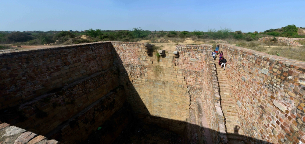
In the functional palace area, there are the remains of a rectangular baoli and a well which served as a provision for water. These are located near the south gate. The baoli is located to the east of the south gate. It is a rectangular rain-fed tank with stairs leading down. There are remains of a pulley system which could be used to haul up water. This is located on the northern side of the baoli. Further east in front of the citadel wall, there is a defensive ditch, whose facing stones have now disappeared. It too could have been used as a water source even though that was not its primary purpose. The well is a short distance to the west of the tank and north of the south gate. Its mouth is contained in a mound.
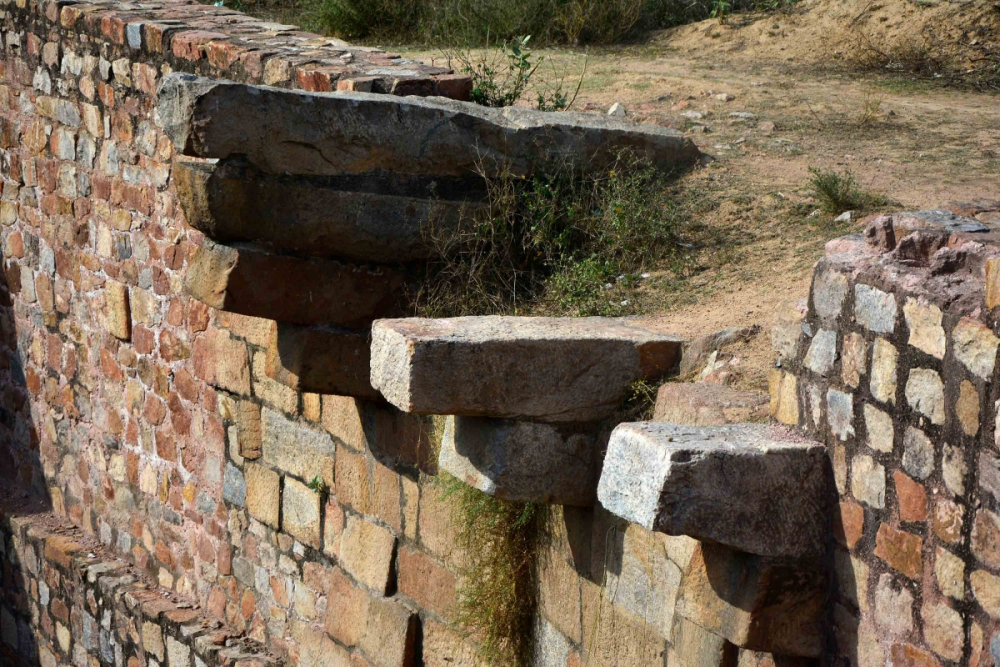
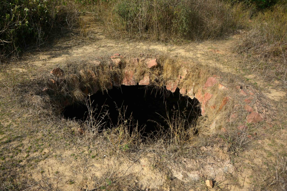
Food silos too seem to be located next to the gate, and indeed run along the southern wall of the functional palace area from the south gate to its western edge. Over one of these is a room with the framework of a lid to the silo which would have doubled as a floor of the room. These silos could, therefore, have been underground silos. Such silos can be seen next to the north gate as well. In between the north and south gates are the remains of over- the-ground silos.
In the functional palace area are remains of what appears to be a large audience hall. It is located towards the eastern end of the palace area. It is one of a complex of ruins. This rectangular south-north hall which forms the northern part of this complex, starts from a multi-storied terraced building somewhat recessed to the south and ends in a ruined arched gate to its north. On its western and eastern sides run colonnades from south to the north. It would seem that the sultan sat on one of the terraces with the sun behind him and looked towards the north. Those who had to attend stood in rows and faced the sultan. They would have been shielded from the sun by tenting supported by a large number of pillars, whose bases can be seen today. Entrances to the hall are from the west and the east through middle of the colonnades. The sultan’s entrance seems to have been not from the east, but from the southern end of the hall complex. The arch at the northern end leads to a smaller complex of rooms enclosing a smaller yard, which could have been some sort of secretariat.
It is not possible, as of now, to determine the nature of the buildings to the north and to the west of the terraced multi-storied structure, which formed one end of what might have been the hall of audience. Between the complex containing the hall of audience and the east gate as well as towards the north-west end of the palace area are areas free of stone and presumably stone structures. They are surmised to be fields.
To the east of the palace lies the smallest part of the fort, the citadel. It is the most strongly defended part of the fort. On its west lay the palace, north lay the city and to its east and south was the lake. From the palace it was defended by high walls with a broad defensive ditch in front of them. This defensive ditch could have been an additional source of water to the palace area where it was located. Just behind or east of the defensive ditch was a horned outwork defending the entry gate into the citadel, with a covered way to its north with arrow slits facing the ditch and the area behind the ditch. The roof of the covered way provided a second rung of defences whose crenellations are no more there. The entry gate was not only recessed between two deep bastions, but defended by a horned outwork fronted by the defensive ditch. Today the entry is from a path leading from a gate on the southern wall of the palace attached to the causeway. This, however, is a modern path made by the ASI for the convenience of visitors. The actual entrance was from the northern side. The entry from the north into this horned outwork was prefaced by a long passage flanked by the dominating fort wall to its east and a covered way to its west. After entry, into the horned outwork, a leftward turn led to the citadel entrance. The entrance for tourists today leads to the functional area from where a path leads to the horned outwork in front of the citadel.
The citadel is much smaller than the palace area and has four large dominating bastions at its north-west, south-west, north-east and the south-east corners. Points of interest in the citadel are a mosque, a tank, palace walls, two escape passages one in the southern wall and one in the eastern wall, silos near the entry gate, the citadel’s defences, in its centre the highest part of the fort, Bijay Mandal or Badi Manzil and to its east running on a north-south axis a set of underground chambers or teh-khanas. There are ruins of residential buildings as well but it is not clear whether they belong to the Tughlaq era or to a later squatter population. In fact even the mosque could belong to a later squatter era.
The citadel is the only part of the fort which has three tiers of defences. Its walls are appreciably higher than those of the palace area, whose walls themselves are higher than those defending the city. These citadel defences can be seen on its southern wall facing the lake cum marsh. The high southern defensive wall has bastions at close intervals. These show evidence of having been repeatedly buttressed more at the base than higher up to strengthen them. The curtains too have been similarly buttressed. Besides strengthening the walls, this buttressing have the effect of giving them a convex apron, which limits the angle at which any escalading ladder can be placed so that the attackers are silhouetted for a convenient arrow shot for the defenders. The first line of defence is an external walkway with arrow slits located at the bottom offering a close angled shots at the foot of the walls. Above that is covered passage offering a distance shot. These are angled sideways to provide overlapping fields of projectile shower. The roof of this covered passage provides for the third tier of defences, where the spaces in the crenellations provide for arrow slits. At other places of the fort the external walkway does not occur. At other places, there are only two tiers of defence. There the covered passage has two distinct sets of arrow slits; the lower one providing for close angled shots at the foot of the wall and the areas next to it, while the one above it are angled overlapping arrow shots at distant targets. In the citadel alone are these two set of arrow slits bifurcated into two distinct sets of defensive tiers.
While gates, including the citadel gate, appear open to the sky today, they were actually covered. Just behind the entry to the citadel, on both the northern as well as the southern end of the citadel gate were guard rooms of which only the southern one survives as of now. Immediately behind the gate, which is to the east of the northern end of the gate, are ruins of the grain silos. To the east of the southern end of the citadel gate is the mosque with its courtyard. It has no dome but a sloping roof over its iwan (a rectangular space, usually vaulted, with walls on three sides and one open side), the iwan is too small to accommodate domes. One such mosque exists in Lodi Gardens, but it belongs to a later era. This is the reason for suspecting that the citadel mosque could have been a later period mosque. However, the smaller size of the iwan could have just as well forced the builders to opt for a sloping roof in the Tughlaq era.
A short distance south from the mosque are the remains of a rectangular water tank almost 15 metres deep. This would have been the source of water supply for the citadel. To the east of the tank is a wall with arrow slits. This defends an inner area within the citadel itself. This makes sense only if it separated the Sultan’s personal living palace from the other areas of the citadel. An entry located at the southern end of this wall leads to the Sultan’s personal area or palace. East of this wall lies a north-south series of teh-khanas, or underground chambers. The entry to theses chambers lie at the southern end as well as the northern end, which lies to the east of the mosque. At intervals there are openings on the eastern side of this long series of chambers. These would have provided ventilation and light to an otherwise enclosed space. There is evidence that there were dwelling units or chambers above these teh-khanas, so that these would be insulated from the extremes of temperature.
To the east of the line of teh-khanas rises Bijay Mandal or Badi Manzil. Today a flight of steps leads to the top. This is a recent provision. Access to the top was perhaps provided by two covered inclined passages to its north and south. On top, a base of a square chamber with openings in each of its four sides can be seen. This is the highest spot in the fort and from it the entire city, functional palace area and the citadel as well as the outwork containing Tughlaq’s tomb can be seen. From here, fragments of wall to its east and north can be seen. These together with the wall to its west that has already been mentioned, and one presumably to its south would have formed the sultan’s personal palace. Dwelling units including two-storied buildings too can be seen, though their belonging to that period cannot be vouched for with certainty. The point of interest however is, that they consist of rooms that are clustered around and open out only onto a central courtyard. These rooms have no openings, not even windows to the outside. The central courtyard is open to the sky and has a single opening to the outside. This type of plan has been noticed in India for a long time and can be seen in the Indus civilization housing as well, even though it cannot be surmised therefrom that there was a continuity of design from that period.
Almost midway in the southern side of the citadel near the wall is a flight of steps going eastwards below ground. This then turns right southwards to a low passage with gates. This passage which is entirely hidden in the width of the fortification wall, exits the south wall, but at a height from the water level of the lake. It is the height of the exit above the lake and the drop that it entails that argues against it being a secret escape, which it could have been. It could alternatively been a passage for disposals.
There is a more credible secret escape route in the eastern wall, though it is barely discernible today. It starts with an entrance into the wall leading to a few steps downwards and then turns left northwards along a downward sloping ramp passage concealed within the thickness of the fort wall. At the foot of the ramp there is a right turn eastwards, which exits the passage and the fort wall. Just outside the exit are steps leading to the water level. These steps are partially hidden from the city by the northeast bastion of the citadel.
The defences also protect a much greater area of the city which lies to the south and to the east of the of the palace and citadel complex. Seen from the palace-citadel complex, they appear like a trapezium with a longer side to the south and a shorter side to the north. These walls go eastwards, starting from just north of the north-east corner of the citadel till the bund or the former dam across the stream that was dammed to make a lake. This stream’s bed lay below and on the same alignment as the Mehrauli-Badarpur road. It is separated from the road by the width of a field. This field today houses a school and serves as a playing field for the residents of the present-day village in the city area. The wall then turn south towards the bund stopping short of the Mehrauli-Badarpur road by a system of underground sluices designed to allow the excess water of the lake to escape along its stream bed. Thereafter, the walls turn east and run almost parallel to the Mehrauli-Badarpur road for a short distance. This is the city’s southern wall. This stretch including its twists and turns would be one approximately one kilometre. Then the fortifications turn northwards for a distance of about one and a half kilometres. This forms the city’s eastern wall. From there it turns westwards to form the northern stretch of the city wall. This northern stretch of the fortification is about 800 metres. Then the city fort wall turns and runs south of south west for about a kilometre till it touches the northwest corner of the palace. These are the outer walls of the city. The rest of the city abuts against the palace and the citadel.
Three gates are discernible on the city’s southern wall. One of these opens on to the field (the former lake) with a flight of steps, another to its east leads to the bund and the last is further to the east opens on to where the former stream flowed after it was let through the sluice gates. Since they open on to a water body or on to the bund, the planners of the fort did not think it necessary to erect horned outworks to protect them. There are three gates on the eastern wall, all with horned outworks. Interestingly, the middle gate has only one instead of the usual two horns. The shorter northern wall has two gates and the western wall another two. Since these had no water body and hence no obstacle they were protected by horned outworks. The area of just the city itself, i.e., excluding the palace and the citadel, is approximately 100 hectares. This makes it a sizable medieval city. If the perimeter of the entire complex including the palace and the citadel is considered, it would be about six kilometres enclosing an area of approximately 130 hectares. With ten gates of the city and two of the palace that open to the outside, there are 12 formal gates to the complex. To this the entrance to the palace from the causeway may be added to make the number of formal entrances to the entire complex 13.
The spread of the village inside the fort has destroyed features. A water tank marks the spot where the Jami Masjid or the city’s congregational mosque once stood. It stood about midway between the palace’s eastern gate and the middle gate on the city’s eastern wall, which as has been mentioned had only one horned outwork. From the northern gate on the west wall there is a still discernible path apparently broader than the other paths so that it could be surmised to be the principal processional path leading to the northern gate of the palace as was mentioned earlier.
The description of Tughlaqabad would be incomplete without an account of Ghiyas al Din Tughlaq’s tomb and Adilabad, both of which are an integral part of the complex. This tomb and that of Ghiyas-ud-din’s son Zafar Khan, who predeceased him, are both located in the irregular pentangular fortification which had been constructed to deny any potential attacker a lodgement on the irregular outcrop, built over the water level in the vicinity of the palace and citadel walls of the fort. Construction of this fortification was an necessity because without it an enemy who obtained lodgement on this outcrop could use it to erect a meachanism to hurl heavy stone projectiles at the wall to weaken them; or burning arrows to start fires or even the rotting carcasses of animals which could cause a disease. This fortification has five bastions at each one of its five corners. It was designed to be an autonomous defensive unit attached to the palace by a defended causeway supported by 27 arches through which the water of the stream cum lake flowed. Today it is silted up almost to the level of the arches. The entrance to this fortification is through a decorative gateway made of red sandstone, flanked by pilasters and a touch of marble. This is unusual and its justification is only because of the tombs inside.
This fortification has two underground grain silos in the eastern bastion. For water there is a well located outside just adjacent against its southern wall. To prevent its water from being contaminated by flood waters of the lake, its mouth has been placed in an elevated platform built to a height thought to be sufficiently high to prevent flood waters from entering the well. To permit access during a siege a cantilevered, protected platform was placed directly above the well, with an opening in its floor to allow buckets on a rope to be lowered and drawn up. All its five walls had defences consisting of a covered passage with a parapet above. In the interior, a number of independent teh-khanas each with it is own staircase can be found on the southern side. In the two bastions to north and south west are tombs of Zafar Khan and the ruins some decorative structure, respectively. Zafar khan’s tomb seems to be the earliest tomb with a marble dome in Delhi.
More to the western end of this pentangular fortification on the inside rises the marble-dome–topped red sandstone tomb of Ghiyas al Din Tughlaq with its high sandstone finial. The four walls of its square base are not parallel to any of the walls of the fortification. This is because the tomb had to have a cardinal point orientation, whereas the walls had to follow the shape of the outcrop. The tomb’s sandstone veneered walls have an external batter and have an entrance from the east, north and south. The western wall has no entrance because it has a mihrab on the inside. The top of the entrance arch has a string of sandstone inverted lotus buds. To provide relief from the red colour, panels of marble and black stone have been embedded on the top of the walls. The dome is made of marble topped by a high sandstone finial. There are three tombstones with a veneer of polished limestone plaster inside the chamber. The one in the centre of the square chamber is that of Ghiyas al Din Tughlaq. The one next to it and to its east is possibly that of Mehmood Khan who was his son and died at the same time as he. The one to the east of that is that of a woman, who could be the sultan’s wife who died many years later. Once again there is a legend associated with the Sufi saint Nizam al Din that is connected with the deaths of Ghiyas Tughlaq and Mehmood Khan his son. Relations between the sultan and the saint were said to be strained, and the sultan who was campaigning in Lakhnauti is said to have planned measures against the saint. The saint Nizam al Din was not perturbed when told of this and is said to have uttered the words ‘Dehli dur ast’, which translate as 'Delhi is (as yet) far away'. Both the sultan and Mehmood were killed in the collapse of a wooden pavilion just a short distance from Delhi.
The bund which dammed the stream to form a lake on the southern side of the fortification had to be defended. Otherwise, any attacker could breach the bund and drain the lake thereby depriving the fort of its southern obstacle defence. The bund is actually defended on its northern flank by the Tughlaqabad fortification, and the southern flank by another fortification known today as Adilabad. These two fortifications are joined by a fort wall which defends it from the east. The lake seems to have been deemed to be its western defence. As a part of the necessary defences of the bund/dam, Adilabad had to be built at the same time as the main fortification and would have been built by Ghiyas al Din Tughlaq and not at a later date by his son and successor Mohammad Tughlaq, as is claimed by some on the grounds that Mohammad Tughlaq was known as Adil ('The Just'), and that the fort being known as Adilabad would have been constructed by him. However, there is what appears to be a large audience hall built on a south-to-north orientation within the this fortification, which could have been built by Mohammad Tughlaq as a result of which the fortification itself came to be known as Adilabad. This hall is in the inner keep separated from the outer defences by a bailey. It can be approached from the west by the lake. The western approach leads to a ramp and then a set of very broad steps, which on account of their breadth are known today as elephant steps. Another approach is via the bund which leads to a gate to the inner keep in the east, which has a horned outwork as it is not protected by a water body. There is an entrance to the outer defences from a gate to the south east which opens on dry land and therefore has a horned outwork.
When the Adilabad fortification is viewed from east, it becomes evident that the ground to the east of the bund is appreciably lower than the ground on its west where the lake once stood. From this the degree of silting of the former lake can be gauged and the depth of water in the lake at its greatest extent. If the Adilabad fortification and the pentangular fortification is added to the main fortification, the size of the fortification and the area covered becomes larger still.