
Of all the cities in India, Delhi perhaps is the only one that can boast of a history of traditional water management going back several centuries. Each epoch has left its imprint of wise water traditions but, sadly, the newest has little to add by way of wisdom; it is a study in mismanaging water in a city that has survived a semi-arid climate for millennia.
Geographically, Delhi grew on the west bank of the Yamuna River; there are no significant monuments on the eastern side that testify to a civilisation. That part was the floodplain of the river. Indraprastha probably existed at the site of Purana Qila. Its inhabitants would have drawn water from the river directly through wells, or dug wells for water if they lived at a distance from it. Later cities grew on the same site, further south in the Aravallis and north in the Red Fort area.
These are different zones in Delhi. The city can be broadly divided into the Yamuna floodplains that is mostly sandy and alluvial, and the rocky landscape of the Aravalli Hills. Each had its own take on how to manage water. In the floodplains, it was a question of managing water, channelling it to where it was needed and using it. In the Aravallis, it was a question of conserving water during the rainy season to have enough to use through the year. Thus, there is a diversity of water structures in Delhi.
The area where Indraprastha may have existed is low-lying with high groundwater levels. Dugwells and, possibly, stepwells would have been how they got water for their needs. Additionally, the Aravallis formed a watershed to the south and west of the ancient city, its forest and natural depressions feeding seasonal streams that kept the wells full of water.
Making Design Fit the Context
As Delhi is divided into rocky and alluvial regions, with the Aravalli hills comprising the former and the flatlands of the central and eastern parts of the city, the latter, each had its own way to access water and store rainwater. For example, in the rocky areas, natural depressions stored rainwater. Or, as in the case of Neela Hauz in South Delhi, a low wall constructed across a stream held up water behind it.
The alluvial Yamuna floodplains have a ‘lens’ or sweet water aquifer above a saline aquifer, according to the Central Ground Water Board. The sweet water aquifer lies at a depth of 40–70 m below ground level. There is more usable groundwater in North Delhi than in South Delhi. This underpinned most of the techniques for accessing groundwater such as wells and baolis, determining their location and depth.
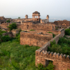
Diverting water along the Aravallis was an art form. From the south-west, water was channelled through natural drains and ponds in the hills through dams such as the Satpula dam in Saket. This probably held back the water from a stream originating in Khanpur and flowing north; the stream is now the Defence Colony nallah, or Saket drain, another sewage canal and testimony to failed urban development. From this dam, the water was diverted towards Tughlaqabad Fort into a lake in front that formed part of its moat and kept groundwater levels high so there was water in the seven baolis (stepwells) inside the Fort. Thus, in this rocky area wells were few and far between and people used surface water stored in ponds.
In the central parts of the city, dugwells were the preferred method of getting water since the soil was soft and groundwater was abundant. In 1843, according to one source of information, Shahjahanabad had 600 wells, both public and private, for water. Of these, about 60 provided sweet water for drinking while the rest yielded brackish water that was used for non-potable purposes, or by those who could not use the sweet-water wells.[1] Several houses in the Walled City still use wells, only they draw water through electric pumps submerged in the wells. Dugwells are 40–60 feet deep and usually reach only the surface aquifers. The modern version of dugwells, the tube-well, took over in the 1970s with the rapid expansion of the city. In most parts of central and eastern Delhi, groundwater was available at depths of 60 feet from the surface then; it has since sunk to over 150 feet.
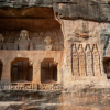
Wells and their sister structures, baolis, formed the centrepiece of oases built by merchants or rulers along trade routes. Called sarais, each was built around a water source for caravans. Some were wells, others were the more spectacular baolis, or stepwells. Several still survive, such as Agrasen ki Baoli in Connaught Place, Gandak ki Baoli in Mehrauli, the baolis of Tughlaqabad Fort, Firozshah Kotla, and something that looks like a baoli in Sanjay Van that probably belonged to Lal Kot, the city of the Anangpal Rajputs. Baolis were common to both regions.
For each city, the rulers secured water in keeping with the location. When Firozshah Kotla was built, water from the Yamuna was channelled through the Fort to ensure the wells had water through the year. The city stretched from Bara Hindu Rao in the north to Old Fort in the south. There is a circular baoli in the citadel, the only one to survive. The old water channels have been destroyed and the materials used to build Old Fort and later, the Red Fort. This has continued to this day.
Other less well-recorded water systems existed in what is now Dwarka and Chhatarpur. The villages of south-west Delhi had their own ponds. One record mentions a large lake at what is now Dwarka that was probably the Najafgarh lake; this has since shrunk to a shadow of its former self. In the Chhatarpur area, the Gadaipur Bandh still exists, as do several others. They regulated water from the hills flowing north to the south into the Chhatarpur basin.
Delhi therefore had streams, ponds, wells, baolis and the Yamuna River. This makes for an interesting and eclectic mix of water resources for the ancient city. Streams connected to the ponds were dammed to store water and recharge wells and baolis. They all eventually joined the Yamuna River. The health of one was critical for the health of the overall system as they were interconnected. Delhi had some 800 waterbodies, natural and man-made, according to the Indian National Trust for Art and Cultural Heritage.[2] Many still survive but are not recognisable as waterbodies anymore; some are just little puddles while many others are covered with muck and water hyacinth. Let us examine these different aspects individually.
- Streams and rivers
Delhi has a large network of streams, most of which have become sewage channels in the past 3–4 decades. The most prominent is the Sahibi River, a seasonal stream that rises in the Sirmaur Hills in Rajasthan, flows through Haryana and Delhi before joining the Yamuna shortly after it enters the city. It used to carry only rainwater, from Haryana to Delhi, in season but now is a sewage canal called the Najafgarh drain, and the biggest source of polluted water in the Yamuna River. This river and its tributaries, flowing west of the Aravallis, maintained groundwater levels in ancient Delhi.
At the south-western end of Delhi where it enters the city, the river formed the Najafgarh Lake. Till the 1970s, this seasonal lake covered several hundreds of hectares. From the 1970s, the city’s flood control department deepened the river and made dykes to drain the lake on the pretext of protecting the city from floods. Several large drains connecting to the river have started carrying only sewage owing to inadequate network coverage in the city. One of the large ones is the Palam drain. The Najafgarh drain splits into two at the Kakrola regulator. The northern branch, called the supplementary drain, eventually rejoins the main channel just before it meets the Yamuna River.
Most of the streams from the Aravallis in the south collected at the Barapulla dam near the Nizamuddin Railway Station. One prominent system is the Neela Hauz, part of a series of channels and ponds that flowed into the Hauz Khas tank, built by Alauddin Khilji. From there, water flowed through a stream to join the Sarojini Nagar nallah and onto the Barapulla dam. The latter portion is hard to trace because it has been covered up in most parts.
The streams from the Central Ridge are harder to trace as that part of Delhi was built earlier. It is safe to assume several streams originated from this part of the Aravalli Ridge, flowed around Raisina Hill and into the Yamuna River. The land is flat east of Raisina Hill, leaving their route open to speculation. However, one stream emerges near ITO and flows between that area and Pragati Maidan to join the Yamuna near the Indraprastha Power Station.
An old map of Delhi shows a storm water drain starting in the Central Ridge behind Mandir Marg. The Tughlaqs probably made several water conservation structures here, of which a few survive. The Bhooli Bhatiyari, a hunting lodge in the Central Ridge, must have had as its own source of water, either a pond or a stepwell, to provide water for men and animals. The storm water drain starts about there, flows south around Rashtrapati Bhawan and then east to the Yamuna, becoming one of the main streams to join the river at Barapulla. On the way, it is joined by a small drain that starts somewhere in the Lodhi Gardens. In the park, the Athpula Bridge built by the Lodhis spanned this drain testifying to its existence at an earlier time.
In North Delhi, the Northern Ridge, where the Aravallis finally taper down into the Yamuna River, a fork of the Sahibi River flows north while another flows south of the hilly area. They meet just before joining the Yamuna River at Wazirabad. Several small seasonal streams join these two branches as well.
These seasonal streams were critical to Delhi’s water system to bring down the annual monsoon waters to different parts of the settlement. The baolis and wells made near them were assured of a regular recharge during the rainy season. In places, small dams retained their water or diverted them to other parts of the city as needed. Mohammad Bin Tughlaq, for example, used the Satpula dam to channel water from the Mehrauli area to Tughlaqabad. In addition to water from the catchment to the south in Aravallis, this added to the lake around the Fort.
About 18 large and medium drains enter the river at various points between Wazirabad and Okhla. The largest is the Najafgarh drain on the western side. On the eastern side, it is the Shahdara drain. Further south, it is the collective of drains at the Barapulla.
In modern Delhi, these seasonal streams have become sewage drains. In fact, they have all been renamed appropriately. Thus, the Sahibi has become the Najafgarh drain. Far from helping the drainage or water security of Delhi, this myopic approach has led to massive pollution of groundwater from the untreated sewage that flows in these drains.
By draining the Najafgarh Lake, the city’s authorities have created a groundwater emergency in south and south-west Delhi. This lake shored up the aquifers in this part of the city but since its drainage, groundwater levels have fallen sharply. Additionally, the city has been deprived of the moderating effects of water on the climate.[3]
- Baolis
The best-preserved baoli is probably Agrasen ki Baoli, built by the eponymous Agrasen who is said to be the founder of the Agrawal clan. It is tucked away between high-rise apartments and office blocks that have come up in the Connaught Place area. Stone and mortar walls indicate that it is a monument. The outside walls of the Baoli have archways that lift the wall to about 15 feet above road level. The entrance is at the southern end, through a barred gate. On either side are plaques explaining the Baoli’s history. There is a masjid at the southern end, near the entrance.
Walk through the arched entrance at the southern end of the Baoli and you are faced with a huge structure that stretches away towards the north. The stone sides reach down into the bowels of the earth, a pathway for people seeking water. Steep stone steps lead down to where the water must have been. There are five visible storeys to the Baoli, about 10 m deep with filthy water at the bottom. The Baoli’s water was used for everything but drinking by people; there is a well adjoining the Baoli to the north. On each floor, archways beckon you to relax in the cool shade; with water in the Baoli, it would be a perfect summer sojourn.
Men and women could bathe in seclusion at the Baoli. An inner chamber has five floors with a central opening for water. Small rooms surround the central opening and this is where people could bathe, pray or camp. Each floor has its own access from the surface so the Baoli’s ‘guest house’ could accommodate several families at the same time; the rest could camp around the Baoli in the archways. Other baolis follow the same architectural principles.
The other baolis that are still recognisable are the Gandak Baoli and Rajon ka Baoli in Mehrauli, a small one in the Old Fort and a round one in Ferozshah Kotla. The baolis of Tughlaqabad take some imagination to visualise as they are very derelict. However, there were seven in the Fort. The one near the main entrance still has stone posts for supporting a pulley to draw water. Stone steps are visible far below. Further inside the Fort is a better-preserved square baoli with steps leading down to what may have been a well. These baolis tapped groundwater that was readily available since the lake outside the Fort kept its level high.
The wonderful thing about the baolis was they brought people to water. Each need was met—watering animals, bathing, drinking and relaxation. They were secular—both Hindu and Muslim traders built baolis or dugwells for people. The stone structure sunk in the ground ensured they remained cool even in the midday heat of May. Most baolis were decorated after the religion of its benefactor. Accordingly, some of them had inscriptions from the Quran while others featured carvings of Hindu gods.
- Ponds and hauzs
Delhi abounds in ponds, both artificial and natural. The Indian National Trust for Art and Cultural Heritage estimates there are about 700 big and small waterbodies, of which just a few are artificial. Some date back to the Tomar Rajputs who ruled the city from AD 736–1192.[4] They constructed several structures in the Aravallis in keeping with the concept of storing surface water. This is reminiscent of Rajasthan where the various Rajput dynasties have used similar approaches, materials and geographies to make hundreds of ponds in the Aravallis.
The largest surviving one is the Anangpur dam in Faridabad that formed the Badhkal lake. This was made by Anangpal, also of the Tomar dynasty, who made Lal Kot, by building a dam between two hills; the other three sides of the lake have low hills. Markings on the stone-faced dam indicate the water levels and there is a large sluice gate in the centre of the dam. The dam irrigated a large area in what is now Faridabad.
Nearby, they also made Suraj Kund, a large circular stone pond that collected rainwater, also made by the same person. This reservoir was built in the shape of the rising sun. It is enclosed within a steep semi-circular embankment made of stepped stones. It fills up during the rains but is dry the rest of the year. A channel used to carry water from the catchment further up the hills but that is blocked by hotels and an illegal housing colony today.
From these early structures in the Aravallis, hauz construction moved to the plains of Delhi during the Sultanate period. Apart from diverting water from the Anangpal structures, the Khiljis made a few hauzs. The most notable is the Hauz Khas pond. This square pond was fed by rainwater from the surrounding forests. To its east are the remains of a mosque and Alauddin Khilji’s tomb. This supplied water to his city that was built between Qila Rai Pithora to the south and Indraprastha to the east. This pond remains an important part of the city’s water heritage.
Hauz Khas covers about 70 acres with an island in the middle. It has been repaired several times, most recently in the 1990s. The sides of the Hauz are pitched with stones and slope down to the water. The bottom is lined with slabs of red sandstone that helps retain water. As part of that effort, water from Neela Hauz was put through a natural cleaning process by spreading it into three lagoons in the surrounding Sanjay Van and diverting it through a series of natural channels to the Hauz. From the Hauz, the overflow reaches a drain along Aurobindo Marg and thence, the Barapulla. The drain along Aurobindo Marg was once a wide seasonal stream.
Water Management in the Old Cities of Delhi
Delhi was home to several invaders who laid the foundation of the seven cities that sprang up in and around of what we now know as Delhi NCR, in different centuries. This section discusses the water management systems in some of these cities which are identifiable even today
- Mehrauli
This ancient village in South Delhi deserves a separate section given its long history and location between the Rajput and Sultanate parts of Delhi. It started life as Mihirawali, established by Anangpal of Suraj Kund fame. It slowly morphed into Mehrauli and was famous for its mango orchards. This village and its surroundings have the most fascinating water conservation structures in the Delhi area.
Starting with Munirka nearby, where there are remains of an old circular pond with a well on the western side, there are remains of several structures in the forests and colonies of the area. The pond in Munirka is about the same size as Suraj Kund, but unlike the more famous pond is of unknown provenance. The surrounding galleries are made of roughly hewn stone while the bottom is also lined with stone without any concrete. Water seeps into the ground soon after it collects.
In Sanjay Van, scattered among the ruins of Lal Kot, are numerous depressions that may have been artificial ponds. One of the largest, Neela Hauz, was probably made by the Chauhan rulers when they built Lal Kot, to store rainwater. They were proficient in making such structures in the Aravallis as the brief rainy season was the only time that water was abundant. This needed to be captured and stored for the long dry spell. In the rocky gullies nearby, there are remains of a stone dam that they may have built.
Just outside Mehrauli are the ruins of Hauz-i-Shamsi, the largest and oldest surviving tank in the region. It was built by Sultan Shamsuddin Iltutmish in 1230, one of the Slave Dynasty kings who ruled Delhi, and is named after him. It is said that the Prophet came to Iltutmish in a dream and pointed out the spot where the hauz of his dreams would be built. In the morning, the king saw the hoofprints of a horse there and built a Hauz around it. He made a large platform in the centre of the Hauz where the hoofprint was and this could only be reached by boats. It was probably much larger than it is now because the platform is now accessible by a ramp from the western side.
Hauz-i-Shamsi now covers about 2.3 hectares and is roughly rectangular. Like the talaabs of Rajasthan, from where its builders seem to have drawn inspiration, it has stone-faced sloping walls that disappear into very murky, mucky and smelly green water. On the western side, the platform with a chhatri extends into the waters, and even on a hot day the breeze from the Hauz acts as a natural air-conditioner. Its catchment, to the north, west and south, is almost completely encroached by buildings. A road runs along the west, blocking water flow. To the south is a sewer that diverts sewage from the Hauz. However, house-owners continue to pollute it with sewage.
The only water in the Hauz is rainwater. While this has ensured it stays clean, it has also reduced the quantity of water. Even so, the Hauz is quite full of water. People use its water for bathing and washing clothes even though it clearly does not appear clean enough. The Hauz was restored a decade ago and is periodically cleaned during the annual Phoolwalon ki Sair Festival. This festival is celebrated at the end of the monsoons at the shrine of the Sufi saint Khwaja Bakhtiyar Kaki, also known as Qutab Sahib. It begins from the Jog Maya Temple in Mehrauli and goes through the village bazaars to the saint’s shrine, that’s across the road from the Jahaz Mahal. Mumtaz Mahal Begum, the wife of the Mughal ruler Akbar Shah II, started the festival in the nineteenth century.
The last time the Hauz was restored, a wall was built with a steel grill atop it to prevent people from using the Hauz as an open-air toilet and garbage bin. At the entrance to the platform, where people can access the Hauz, it is a rubbish dump.
To the north-east of the Hauz is a former pleasure palace called the Jahaz Mahal. Jahaz Mahal does not show any signs of its colourful past, save for the handful of blue tiles set in the domes. It was probably made by the Lodhis a few centuries after the Hauz was built when the place was greener and the Hauz flowed past the Mahal into the forests to the east. The chhatris atop Jahaz Mahal still sport a few of the original blue-green glazed tiles although most have fallen off during the centuries. It was a large central hall surrounded by smaller rooms with jharokas. The building was also surrounded by a moat that is now dry. The jharokas, also all gone, extended over the moat. Presumably, it was shaped like a ship with the moat giving the impression of a building floating on water.
There is a breath-taking view of the Hauz from the top of the Mahal. The breeze coming off the Hauz is cool and strong, even in the late morning heat. This gives an idea of how the other hauzs and baolis provided an oasis in the searing summer heat.
Water from the Hauz used to flow through a small channel to the east into a little garden called Jharna. This was also built by Iltutmish and restored by later rulers. The garden covers about 1,500 square yards. Water from Shams-i-Hauz flowed through the underground channel to one end of this garden, cascading down its side into a small covered area and flowed through shallow channels to cool the place. In the centre is a domed platform with a water channel running beneath, to keep it cool. From here, the water flowed to the end of Jharna and into the forests of Mehrauli. This was a pleasure palace for the kings who travelled here in the summer to savour Mehrauli’s fabled mangoes.
Water from Jharna flowed into a natural drain that carried it east to the Satpula dam about 4 km away. There, impounded, it provided water to settlements and further fed the lake outside Tughlaqabad. This was one water system of ancient Delhi spanning a few centuries of early Muslim rule.
The large Qutab complex on the other side of Mehrauli has three baolis. The oldest of the three baolis, Anangpal Baoli, was built in the eleventh century by Anangpal as part of Lal Kot. Gandhak ki Baoli is believed to have been built during the thirteenth century during the rule of Iltutmish. Its water, when there was some, apparently was rich in sulphur and had healing qualities. Finally, Rajon ki Baoli was built during the sixteenth century by the Lodhis. None of these baolis have any water now as the groundwater level in the Mehrauli area is extremely low.
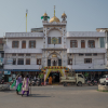
- Shahjahanabad
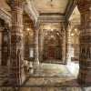
This city came up on the banks of the Yamuna River. Its approach to water was different because of its abundance. Instead of storing water, the Mughals managed its flow. They diverted the Yamuna and Sahibi rivers to their advantage. To raise the river waters to the Fort, they probably used Persian wheels driven either by the flow of the river or draught animals. For the Mughal capital of Shahjahanabad, an elaborate water system was constructed. The city was divided into the Red Fort for the army and royalty, and the walled city for the rest.
Shah Jahan, the Mughal emperor who ordered the city to be built, asked his chief engineer Ali Mardan to ensure the city never ran out of water. Mardan’s canal linked the Yamuna with the Sahibi to create a complex of canals that ran through the city. The waters of the canals recharged the wells and dighis, a small square reservoir into which canal waters flowed. The 600-odd wells and dighis were both publicly and privately owned. If the canals ran dry, the wells continued providing water for the city. Some of the richer households employed bishtis, men who drew water from a dighi in a leather hogshead and brought it into their bathrooms or kitchens, and also watered their lawns.
The main street in Chandni Chowk was originally a canal fed by Mardan’s feat of engineering. Till 1910, the canal ran between the rows of shops and was finally buried under the street to provide space for commerce by the British.[5]
The buildings of the Red Fort are connected by a fibril network of canals that carried water from source to discharge. Each building has both exposed and covered water channels. These were the Fort’s air-conditioning system. Strategically located ponds with pavilions allowed nobles to rest in relative comfort and privacy. The water channels also fed the baths of the emperor and his harem allowing them to conduct their ablutions in privacy.
Building Material for Water Management Systems in Delhi
All the water storage structures in Delhi have been made of stone. This is a locally abundant building material. Bricks have not been used at all, save in the sewer systems made by the British. Even these have been replaced by concrete pipes over the last few decades. In the hauzs, stones were used for the facing without concrete to allow water to percolate through the walls. This was a safety measure and also a way to let the land downstream get a steady supply of water for cultivation.
Challenges of Modernity
As Delhi has grown, it has built over its waterbodies, baolis and wells. From a city that used what water was available locally, Delhi now has to depend on external sources. It has treaties with other states to share the Yamuna’s waters and those of the Tehri Dam in Uttarakhand. However, with a little common sense, Delhi can reduce its dependence on these external, vulnerable, sources to a significant extent. Modernity has not brought with it the wisdom to augment, conserve and recycle the local water sources. This has worsened water availability during the dry season and floods during the monsoons.
Studies have shown that rainwater is conserved in all public parks and buildings, and along the Yamuna floodplains, with which the city can meet its own water needs for about three months in a year. This means a 25% reduction in its external dependence.[6] Not only will rainwater harvesting make water available in a decentralised manner across the city, it will also reduce the city’s freshwater withdrawals from the Yamuna River. This is a simple way to mitigate floods as well.
It also has huge implications for the Yamuna River, one of the most polluted in the world. When it enters the city the river has freshwater capable of supporting life. This is completely sucked out at the Wazirabad barrage for treatment and supply to the city. A little downstream the Sahibi River, now the Najafgarh drain, joins the river and refills it with sewage. Another 18 large and small drains similarly pump in sewage so that by the time it exits the city, the Yamuna River is a sewage canal. Its pollution is so intense that it cannot support any aquatic life.
One suggestion in the 1980s was to construct sewage treatment plants on each of the drains before they enter the river so only treated water reaches it. This proves technically and financially impossible. However, Delhi Jal Board is persisting with constructing an interceptor sewer that will carry sewage to a treatment facility in the south of the city before discharging it into the river for Haryana to use.
An alternative is to treat water in the Najafgarh drain, in-situ, before it enters the river. The floodplains can be converted into a giant artificial wetland by channelling the drain’s water across it through shallow channels. Planted with the right local grasses, these channels will naturally aerate the water. The grasses will draw out the nutrients in the water. The combined effect will be to reduce the pollution load significantly with a low running cost.
For this, the drain has to be extended across the river in a channel with outlets at regular intervals. From this transverse channel, water will be let into the wetland through sluice gates. The wetland will then do its work of cleaning the water naturally. During the monsoons, it is likely the entire floodplain will be submerged and may need to be restored once the water recedes. The advantages are that the system will need minimal electricity to run, can be maintained by the farmer tending crops on the floodplains, and requires no special expertise for upkeep.
A third measure is to force Delhiites to conserve water by using water-efficient plumbing. Shower heads, toilets and taps that use a quarter the amount of water used by conventional fixtures are available. These should be mandated in building bye-laws. People should water lawns only with treated sewage water. There must be a ban on washing cars with pipes. As long as Delhi continues getting water without much trouble, the incentive to reduce, reuse and recycle will be very little. It needs more than good intentions to punitive action to make the change.
Notes
[1] www.rainwaterharvesting.org, accessed on 26 February, 2017.
[2] Conservation of Water bodies of Delhi. 2008. Indian National Trust for Art and Cultural Heritage, New Delhi.
[3] http://delhi.gov.in/wps/wcm/connect/doit_irrigation/Irrigation+and+Flood+Control/Extra2/, accessed on 26 February 2017.
[4] www.monumentsofdelhi.com/rulers, accessed on 26 February, 2017.
[5] www.rainwaterharvesting.org, accessed on 26 February, 2017.
[6] This was an estimate by Centre for Science and Environment and Delhi Jal Board prepared at a meeting to discuss rainwater harvesting for Delhi. The CEO of DJB, Chief Engineer of Projects, CSE staff and NGO experts were present. The long-term average rainfall was taken to work out gross availability and multiplied by a factor of 0.8 for built-up areas (calculated by the Delhi Development Authority) and 0.2 for non-built-up areas to arrive at this figure. It was estimated in 2012.