
The valley of Kashmir, located in the lap of the Western Himalayas, has Pleistocene[1] loess[2] deposits which are considered the thickest and most extensive in the Indian subcontinent. In relation to the terrestrial palaeoenvironmental changes these deposits serve as the best and most important archive. The valley is flanked by the Himalayas to the north-east and Pir-Panjal Range (Panjal Thrust) in the south-west. It presents a unique challenge for palaeoclimatic and archaeological studies. It has a sediment profile of several hundred metres with beautiful exposures caused by tectonic activities and erosion. ‘Several cold-warm oscillations have been witnessed by the area resulting in waxing and waning of glaciers, movement of vegetational belts, sedimentological and geomorphological changes, stable isotopic variations in organic and inorganic deposits’ (Agrawal, 1982:2).
Geologically and geographically speaking, it was around four million years ago (hereafter, mya) that ‘Pir Panjal range was further upthrusted to impound the Himalayan drainage, thus forming a vast lake' (Agrawal et al. 1990:70). Thus the Karewa Lake originated because of the rise of the Pir Panjals. The further rise of the Pir Panjals lifted up the Lower Karewa sediments and pushed the lake towards the Himalayan flank. The Baramulla fault later breached the Pir Panjals and the Jhelum drained out the lake.
A change in climate from subtropical to temperate was caused due to the rising of Pir Panjal to a height ‘where it could block the south-west monsoon from entering the valley’ around c. three mya. By 200 thousand years ago (hereafter, kyr) ‘the primaeval lake shrank and shifted to the Himalayan side, exposing the Karewa sediments of the SSW’ (South South-west). The Jhelum river emerged around 85 kyr and drained the remaining lake deposits (Agrawal et al. 1990:70).
The remnants of the lake beds locally known as karewas[3] form the major source of our knowledge of the geology and archaeology of prehistoric times. These are the Bible for scholars from diverse fields investigating its formation and other related areas. Many scholars have discussed the geology and stratigraphy of these karewas. They have labelled the Lower Karewa as the Hirpur formation and the Upper Karewa as the Nagum formation. Lower Karewa represents various sedimentary situations like shore-margin deposits, while the Upper Karewa deposits represent shallow water, lake delta beds. Loess is mostly wind-blown, punctuated with minor fluvial episodes (Agrawal 1982:2).
Perhaps uniquely in Asia, Kashmir provides a sequence of continuous sedimentary records of unconsolidated lacustrine deposits which go back c. four mya. For almost a century now, the relic sediments of Kashmir have attracted scholars from diverse disciplines including geology, palaeontology, palaeobotany and archaeology. Investigation of the Ice Ages in India and associated human remains led by H. De Terra and T.T.Patterson (1939) are the first endeavours of their kind carried out in the Kashmir valley. The team carried out some explorations and also excavations at many places of Kashmir. Their efforts ended unexpectedly in that they did not find stone tools made by humans in the Kashmir valley, though they and the early explorers were satisfied with the evidence of the three ice ages and four interglacial ages in this western segment of the Himalayas. Terra and Patterson proposed that because of the continued uplift of the outer Himalayas and the extreme cold during the Second Glacial period, humans were not able to sustain themselves, resulting in the absence of the stone tools in Kashmir (Terra and Patterson1939:234).
In 1969, a team from the Archaeological Survey of India (hereafter, ASI) headed by H.D. Sankalia, led excavations in Pahalgam, Kashmir which resulted in the discovery of a massive flake and a crude handaxe from well-stratified deposits of second Glacial and Second Inter Glacial periods respectively (Sankalia 1971:558).[4]
In 1970, another reconnaissance was carried by the ASI under R.V. Joshi and associates, in and around the Pahalgam valley which led to the discovery of nine more tools (Sankalia 1971:558). Two borers[5] were identified at Ganeshpur on the left bank of Liddar, probably of the Third Glacial period, among these nine tools.
As the fossil record of the humans is found very rarely, it is the discovery of stone tools which mainly facilitates the study of the existence and development of human cultures in Kashmir. Following these fascinating discoveries of Palaeolithic tools in Kashmir, interest in stone age archaeology was renewed. The high altitude valleys of Pahalgam, Sind and Rembiara became the points of archaeological reconnaissance.
A multidisciplinary endeavour—Kashmir Palaeoclimatic Project—was initiated to delineate climatic changes witnessed by the Kashmir valley. The team lead by D.P. Agrawal (1982:1-4), during their explorations, reported a Palaeolithic site of a chopper-chopping tool complex, comprising choppers, massive discoids and scrapers on top of a terrace of the Rembiara river valley at Balapura (Shopian) in south Kashmir (Bandey 2009:52).
A.A. Bandey (2009:53) reported many Palaeolithic tools from habitable caves at Manasbal. These include cleavers, hand axes, pointed tools and scrapers of Lower and Middle Palaeolithic period. The location of the Palaeolithic sites, bearing typical tools around the lake shores at Manasbal is testimony to the fact that humans subsequently moved down to lower altitudes and found shelter in these caves.
The location of Palaeolithic sites near lake shores is also testified to by the discovery of these at Bomai, Sopore, in north Kashmir. Here a huge rock shelter was discovered bearing a hand axe along with a prehistoric rock engraving, the first of its kind found in Kashmir. This engraving of the upper Palaeolithic period depicts chase and game engagements of the prehistoric population (Bandey 2009:53).
De Terra and Patterson (1939:233) noticed some stone tools which were described by earlier visitors ‘as flakes of Levallois[6] type’ from Pampur, near Srinagar of middle Palaeolithic period. ‘Thin flakes were also found near Sombur’ representing along with other sites of lower Jhelum terrace ‘a late palaeolithic or proto-neolithic culture’ (Terra and Patterson 1939:233). From the same site stone tools of the upper Palaeolithic period were reported, of smaller size than those found from Bomai and Manasbal. The Somber tool industry comprised burins, points and borers made from jasper, siliceous limestone and trap (Pant et al. 1982:37-40). More than 100 artefacts were collected. These Neolithic tools at Sombur generally appear on top of the loessic plateau, whereas the upper Palaeolithic tool assemblage has been recovered from gullies and the excavated loessic surfaces (Pant et al. 1982:38).
With changes in the environment and ecology soon after Palaeolithic times, there dawned a more comfortable environment in Kashmir which resulted in the mushrooming of Neolithic culture. A new stone tool industry emerged along with the introduction of agricultural practices and the domestication of plants and animals in addition to the manufacture of different types of pottery. The Neolithic culture of Kashmir is represented nearly by four dozen archaeological sites dotting the landscape of Kashmir throughout its length and breadth. The first Neolithic settlement of Kashmir reported by De Terra and Patterson was Burzahom. They also reported a settlement at Nunar (Ganderbal), from where at a depth of seven feet, a Neolithic level was found resembling that of Burzahom Neolithic deposit (Terra and Patterson 1939:234).
Subsequent investigations by the ASI throughout the Jhelum valley, from Anantnag to Pampur, led to the discovery of Neolithic remains at nine sites including Begagund, Gufkral, Hariparigom, Jayadevi-Udar, Olchibag, Pampur, Panzgom, Sombur and Thajiwor (Map 1). The cultural assemblage from these sites include pottery—coarse grey, burnished, combed and gritty red ware, mace heads and celts. Among these sites, Gufkral and Olchibag revealed pit dwellings. These were also noticed at Sempur. Megaliths of Burzahom type were noticed at Begagund, Gufkral, Hariparigom and Pampur (IAR 1962-63:9). Pit dwellings were also noticed at a site on Damodar Udar, some 10 kilometers south-west of Srinagar (IAR 1961-62:98). A polished stone axe and a harvester was reported to be found from Gurahoma-Sangri, on a high terrace near Wular lake resembling the corresponding types found at Burzahom (IAR 1961-62:98). Typical stone tools and pottery of the Neolithic period, and megalithic stones were found from many archeological sites in Kashmir and are mentioned in the Indian Archaeology: A Review reports.[7] Pant and others (Pant et al. 1982:38) reported discovery of 16 new Neolithic sites from Kashmir. A distinct ceramic industry was reported from these sites, comprising ochreous red ware, burnished ware, coarse grey ware, combed ware and gritty red ware. A lithic industry marked by huge chopper-like discoidal cores, borers, flake knives and scrapers was found associated with the typical Neolithic wares.
The Neolithic sites in Kashmir possess aceramic (without pottery) as also ceramic phases of occupation. The aceramic and ceramic Neolithic phenomena was reported from the sites like Kuladur (Baramulla) and Khan Sahab (Budgam) by Pant and others (Pant et al. 1982:38). The aceramic phase of Neolithic culture was also reported from Pyathpathur (Baramulla), Huin, Malpur, Batachar and Nilnag. The stone industry represented at these sites includes thermally fractured stones and tools made on flakes and cores along with grinders and pounders. The tools typically associated with the aceramic phase of Neolithic period from these sites are backed knives, elongated parallel-sided double scrapers and waisted tools (Pant et al. 1982:38).
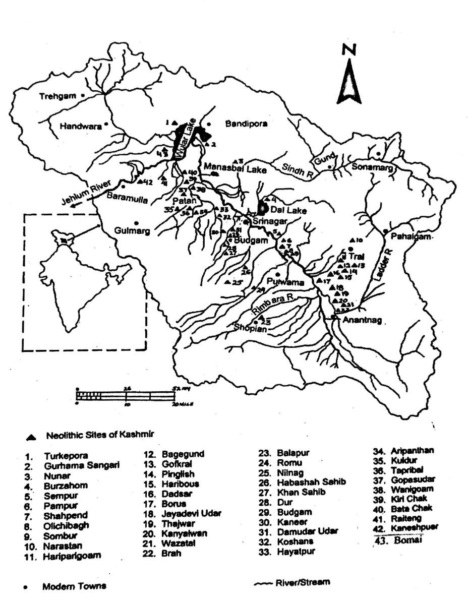
Map 1. Neolithic sites of Kashmir (after Bandey 2009:104)
Of all these Neolithic sites only three—Burzahom (Srinagar), Gufkral (Pulwama) and Kanispora (Baramulla) were subjected to systematic excavations to some extent, albeit without any detailed excavation reports, while there are a number of other Neolithic settlements in Kashmir valley which are yet to be excavated. A brief analysis of the material finds from these sites pertaining to the Neolithic occupation of Kashmir follows:
1. Burzahom
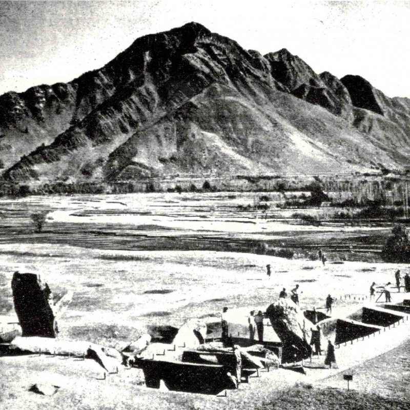
Burzahom (30°10'11''N, 75°51'59''E) is the first protohistoric site reported from Kashmir. It is situated in the east of Srinagar on the Yanderhom Karewa near the foot of Mahadeva mountain, about 1.5 kilometres away from the Dal lake and is presently surrounded by extensive rice fields fed by the waters of Telbal river, which flows to the north-east of the site just below the archaeological mound. The site is capped with 11 megaliths; most of them have fallen down haphazardly and the rest lean awkwardly.
The site was first noticed by Helmut De Terra in 1935. He conducted a small-scale excavation at the site and came to the conclusion that the cultural remains of this site pertained to three different archaeological periods. The earliest of these periods was Neolithic, judging by the cultural remains found at the lowest habitational level consisting of ground stone tools, bone tools and cooking pots. The next period of occupation revealed a copper pin and highly polished black ware with incised geometric design, which were assigned to the chalcolithic period. He associated this period with ‘either a late or an early phase of the Indus Valley cultures’ (Terra & Patterson 1939:234). The final and the third phase of activity was ‘the uppermost layer’ which ‘contains the potsherds belonging to the same Buddhist period as the site of Harwan, which represents the 4th century AD’ (Terra & Patterson 1939:234).[8]
The first systematic large-scale excavation at this site was conducted by T.N. Khazanchi of the Archaeological Survey of India, between 1960 and 1971, with some interruptions. He differentiated the cultural deposits of the site into four periods as listed below,[9] on the basis of the results drawn from the study of several types of structural and other related material remains:
i) Neolithic period I
ii) Neolithic period II
iii) Megalithic period
iv) Early historic period.
The structural remains of Period I consisted of dwelling pits dug into the loess, the natural soil. In plan the pits were circular and square. The circular pits were wide at the bottom tapering towards a narrower top. The largest among them was 2.78 m in diameter at the top and 4.57 m at the bottom and 3.69 m deep (IAR 1961-2:17). At instances steps had been cut into the soil for descending into and ascending from the pits. Sometimes the pits were connected by means of an arched corridor plastered with mud. That these pits had a roofed superstructure is amply attested by the presence of postholes around the periphery of the opening of these pits. The presence of birch, burnt clay, and charred hay inside some of these pits clearly indicates that the roofs were thatched with birch and supported by wooden posts.
Another significant structural activity at the site includes the scooping of square pits. These pits had drains on all four sides as also some ovens made of stone, in the centre. Stone ovens were also found outside these pits on the ground during excavations. This suggests that the people also lived outside these pits, probably when the climate was warmer (Pande 1970:27). Rectangular pits were also found during the excavations at the site. ‘It is interesting to note that the square/rectangular pit chambers were found in the centre of the settlement, while the round/oval ones were at the periphery’ (Singh 2008:111). Some storage pits were also noticed close to dwelling pits with a 60-91 cm diameter containing animal bones, and stone and bone tools.
What was the intent of digging of these pits? Was it really because of the cold weather of Kashmir that people moved into these pits, thereby protecting themselves from the vagaries of harsh winter? It is interesting to note here that the pit dwellings of Neolithic period were also reported from Swat and China. One wonders whether these types of underground constructions were an export from these cultures to Kashmir.The presence of pits at Loebanr III and Kalako-deray in Swat and in Kashmir valley at many sites led to diverse speculations regarding the usage of these pits. The earlier theory that these pits functioned as dwellings is questioned by scholars like R.A.E. Conningham and T.L. Sutherland. Basing their observations on the pit dwellings at British Iron Age sites, studied by P.J. Reynolds, the scholars came up with an alternative view regarding the intention in scooping out such pits. Reynolds proposes that the lighting of fire inside these pits would have made it inconvenient to live inside because of the presence of smoke. The firing inside these pits does not necessarily indicate domestic activities such as cooking etc. Some other uses could be guessed like to prolong the life of pits, to clear mould or damp, or to speed up the drying of the mud plaster inside these pits. The absence of soot on the walls of the pits, which should have been present because of the lighting of fire, is noteworthy. Therefore these pits, in the case of British Iron Age settlements, would have been ideal storage places for dumping the grain for the next season of sowing. People would have moved to the lower slopes and warmer areas during harsh winters. While the majority opinion still sees them as dwellings pits, the theory put forward by Conningham shows how the same evidence can be interpreted in a different way (Singh 2008:112).
The antiquities of Period I include pottery, stone and bone tools etc. The pottery consisted of ill-fired, hand-made and coarse fabric of grey, red and brown colours. These are represented by rimless bowls and bottle shapes with flared rims. The pottery was manufactured on mats, the pot bases bearing mat impressions. Oblong and oval stone axes (some pecked and ground), chisels, axes, grinding stones, ring stones, mace heads and harvesters form the part of the stone industry. Bone tools are well represented by points, harpoons, needles (with and without eyes), awls, spear heads, draggers and scrappers. Tools made from antlers were also found (Singh 2008:111).
The settlement patterning of Burzahom (Period II) underwent tremendous changes. Instead of living underground in pits as was noticed in Period I, people preferred to move out and constructed mud and mud brick houses above the ground. The pits were refilled, leveled and plastered with mud and covered with a thin layer of red ochre.
Human burials formed an essential feature of this period. The dead were usually buried under house floors or in compounds. Both inhumation and secondary burials were practiced. No grave goods were found in burials except some occasional beads around the neck of some of the bodies. A skull of a human body had holes which gives an indication of trepanning. The most important feature of burial practices, however, was the burial of humans sometimes along with wild animals such as deer, wolf, ibex, etc. and domesticated animals like sheep, goat, cattle, buffalo, dog etc. The burial of dogs with humans suggests that pets were buried along with their masters.
The cultural assemblage of Period I continued in Period II with few additions in pottery types and bone and stone tools. Handmade pottery continued to be used with an addition of black burnished ware represented by dish with hollow stand, globular pots, jars and funnel-shaped vase (Singh 2008:113). Black burnished ware was represented by a high necked jar with a flaring rim, globular body, with oblique notches incised on lower part of the neck.
A wheel made vase of orange slipped ware, painted in black with a horned figure paneled between the neck and shoulder bands is significant. A comparison of this has been sought with some wares of pre-Harappan phase at Kot Diji, hinting an import from a nearest site of Sarai Khola. A wheel-made red-ware pot containing 950 beads made of agate and carnelian was also recovered from the same level suggesting an indisputable contact with outside cultures (Thapar 1987:249).
Stone and bone tools were numerous with a better finish than those of Period I. Towards end of Period II a copper arrowhead was also found. Ring stones functioned as mace heads.
Another important aspect present at Burzahom hints towards the aesthetic sense of people. This was the discovery of a stone slab. The slab formed a part of a rectangular structure made of rubble and stone slabs pertaining to phase II of Neolithic Kashmir (IAR 1962-3:Pl. 24A). This slab irregularly cut, is approximately 70 cms wide and is flat on both sides. Partially damaged at the top, the slab bears a hunting scene, incised on the upper half of the stone and has a maximum height of 45 cms. The engraving covers an area of approximately 48×27 cms itself (Pande 1971:135). The scene depicts two human figures hunting a stag, one of them, probably a male attacking the animal from the front with a bow and an arrow. Other person, a female, is attacking the animal from behind with a long spear which has almost pierced through the body of the animal. The stag occupies the central position in the scene—shown with a spotted or stripped body and many branched antler. In the upper part, a dog and two symbols are depicted. The dog has distinctly long, straight ears, long legs and a curved tail. The symbols comprise two concentric circles, with 16 radiating lines all around (Pande 1971:135-6).
This scene is a graphic representation of Neolithic life and the first indubitable example of Neolithic art in India recovered from stratified levels at Burzahom. The hunting scene is very important as it perhaps depicts one of the principal occupations of the Burzahom settlers. The representation of dress and weapons—bow and arrow in the scene are significant. Bone arrow and spear heads were recovered in considerable number from excavations at Burzahom pertaining to Neolithic period, testifying to this type of lifestyle of the people of the contemporary times in Kashmir.
The economy of Burzahom was supported by hunting and fishing. A clear indication in this regard is evident from excavations. Recovery of animal bones, engraved hunting scene on a stone slab, and presence of weaponry like spearheads, arrowheads and harpoons is significant. These people also practiced agriculture, evidences for which are recorded. Harvesters, stone querns, flake knives, mace heads and palaeobotanical remains provide evidence of cultivation of wheat, barley and lentils in the region.
‘The square, rectangular and circular or oval dwelling pits of Neolithic phase I and the entire Neolithic repertoire comprising polished bone and stone tools, pottery with mat impressions at the base and skeletons with red ochre applied on them (particularly from Neolithic phase II and Megalithic) are singularly different in relation to the Indian Neolithic thereby suggesting extra-Indian affiliations of the site’ (Pande 1971:134).
2. Gufkral
Gufkral (33°53'45.67"N, 75°5'40.54"E)[10] is an archaeological site of tremendous importance situated adjacent to Bonmir village in Tral Tehsil of Pulwama district, some 41 kilometres south-east of Srinagar, on the Srinagar-Jammu national highway. It is situated at an altitude of 1671 metres above mean sea level. The site can be approached from Charsoo, Awantipora on its east just six kilometres, as the crow flies, from the national highway.
In Kashmiri, 'guf ' means a cave and 'kral' a potter. This name probably came to be given to this village because a cluster of caves scooped in the Karewa deposit has been excavated there some time in the past, on the slopes of the upper Karewa which are mostly occupied by the present-day potters for the storage of their finished pottery. The Karewa deposit bearing the archaeological material measures 420 metres north-south and 90 metres east-west and is elevated some 35 metres above the road level, roughly occupying an area of three to four hectares. On the eastern side of the mound at the centre of the site, some menhirs[11] (full size as well as broken), can be seen scattered, none of them in their original upright position. The archaeological mound is on top of the upper Karewa and is surrounded by rice fields below.
The site was first reported by the ASI in 1962-63 and excavations were conducted almost near the centre of the mound in 1981-82 by K.D. Banerji and A.K. Sharma of the Prehistoric Branch of Archaeological Survey of India (Mitra 1984:19-25, 104-105; Rao 1985:147,213-14). An area of approximately 100 square metres was opened up having a maximum cultural deposit of 3.10 metres over the loessic silt (Sharma 2013:19). The excavations yielded five occupation levels. Period IA belongs to aceramic Neolithic (2787-2350 BCE); early Neolithic finds were recovered from Period IB (2347-2000 BCE); Period IC has a late Neolithic assemblage (2000-1850 BCE)[12]; Period II belongs to megalithic period (1850-1300 BCE)[13] and Period III is historical in character (Sharma 2013:20). Brief reports of these excavations were published in Indian Archaeology: A Review series (Mitra 1984:19-25, 104-105; Rao 1985:147, 213-14) while a longer report came to light recently in 2013 (Sharma 2013).
The excavations at Gufkral, though they confirmed the three-fold cultural sequence of Burzahom, added some new dimensions to the evolution of the Neolithic culture of Kashmir. Instead of two phases of Neolithic occupation, as reported from Burzahom, Gufkral excavations provided new evidence of the growth and evolution of Neolithic culture in three phases. These phases of Neolithic occupation at the site are labelled as the Period IA, IB and IC (Thapar 1987:248).
The settlers of phase IA of Neolithic period, which was aceramic, resided in underground pits as was observed at Burzahom. The dwelling pits were circular or rectangular in plan. These pits were cut directly into the natural loessic soil and the floors of these pits were often smeared with red ochre. On the surface level around the mouths of these pits some post holes were seen during the excavations suggesting that a thatch cover, probably of birch was supported by the wooden posts over these pits. Near the dwelling pits some shallower pits were also excavated, and probably used for storage purposes.
A large number of bone and stone tools of various types were recovered from this phase of Neolithic occupation. Bone points, needles and scrapper made from bones of various animals including sheep, goat and stag were significant. The stone tools consisted of axes, drills, picks, pounders, querns and mace heads or ring stones mainly made of Himalayan trap. A few tools of antler horns were also reported.
This cultural assemblage from Gufkral suggested that the stone age economy of Kashmir subsisted on food gathering and cereal farming in addition to the domestication of animals. The bones of both wild—ibex, bear, sheep, goat, cattle, Kashmiri stag, etc., and domesticated animals—sheep and goat were reported from the site. The cultivation of wheat, barley and lentils was also important. (Thapar 1987:248).
Phase IB of Neolithic occupation was a continuation of the previous level. For the first time pottery was used at the site. Apart from the animal and plant remains as found from phase IA, some new additions included cattle and dog species and among plants common peas were included. The increasing number of bone remains of domesticated animals and the decreasing number of wild bones of animals is very significant and is suggestive of heavy reliance on the domesticated cattle and settled life style. Bone implements of previous phase continued with addition of harpoons, needles, awls and arrow heads. Chisels, hoes and adzes were additions in stone tools. People continued to reside in pits. Pottery industry comprised of handmade specimens of thick coarse grey ware, fine grey ware and gritty red ware represented by shapes—globular jars and basins with mat impressions on their bases (Thapar 1987:248).
The settlement patterning of the subsequent phase IC (period II at Burzahom) saw some significant changes at Gufkral. Instead of dwelling pits as shelters people moved out, filled the pits and covered them with a thin coat of red ochre and constructed their dwellings of mud or mud bricks over the ground. The tool repository of this phase also underwent considerable changes and innovations. The tools recovered from this level included double-edged pick, spindle whorl, small sized bone points and needles and the harvesters probably used for cutting, scraping and harvesting. The plurality of the tool types suggest of contacts with other regions within and outside this geographic zone.
The ceramic assemblage of the previous periods continued with addition of burnished grey ware represented by high necked globular jars, bowls, basins, etc.(Thapar 1987:248).
iii. Kanispur
Kanispur (34̊ 13′ 35″ N, 74̊ 24′ 30″ to 74̊ 25′ E) also known as Kanispor, Kanispora, or Kanishpura is an archaeological site located seven kilometres east of Baramulla on Baramulla-Srinagar national highway at a distance of 48 kilometres towards west of Srinagar. The site has cultural remains pertaining to Neolithic and early historical period of Kashmir.
The name of this locality is variously associated with the historical township mentioned in Kalhana’s chronicle, Rajatarangini, as Kanishkapura founded by a famous king of Kushana dynasty—Kanishka I (Stein 1900:i.168-70). M. A. Stein has sought this identification of modern Kanispur with Kanishkapura of the Rajatarangini on the basis of glossator Bhataharaka of the 17th century and the Persian chronicles of Kashmir (Stein 1900:i.30.fn.). During Stein’s own time ‘carved stones and ancient coins were occasionally extracted from a mound near Kanispur’ (Stein 1900:i.30,fn; II:482). Pertinently, Stein refutes the identification of Kanispur by Alexander Cunningham (1871:84) with Kampur (Stein 1900:i.30,fn.).
The archaeological ground reconnaissance at Kanispur by the ASI in different seasons led to the discovery of a wide range of material remains (Deshpande 1975:24; Thapar 1980:19; Mitra 1984:16; Mani 2000:1) from the Neolithic to the early historic, Kushana, early and late medieval period of Kashmir.
The site was excavated in three different areas (Misra 2004:30) unearthing 39 quadrants of 17 squares (Mani 2000:2). In Rajteng or KNP1 area, a large structure of diaper pebble walls of the Kushana period as well as habitation deposits of the Neolithic period were unearthed. In KNP2, south of KNP1, a pavement marked by decorated terracotta tiles was unearthed which were arranged in a circular fashion. Neolithic finds were also found here. Only one quadrant of KNP3 was excavated bearing a habitational deposit of around 2.50 metres of the Kushana period overlying the natural soil. This mound, according to the excavator, represents the main township of Kaniskapura founded by Kanishka (Mani 2000:12).
From the excavation at these three areas of the site, the following cultural sequence was discerned:
Period I: Aceramic Neolithic (c. 3rd to 2nd Millennium BCE)
Period II: Ceramic Neolithic (c. 2nd to 1st Millennium BCE)
Period III: Kushana (c. 1st to 4th century CE)
Period IV: post Kushana (c. 4th to 6th century CE)
Period V: Kashmir dynasty (7th to 10th century CE)
The Neolithic aceramic levels (Period I) at Kanispur were 15 to 20 cm thick. The average thickness of ceramic level of Period II was 1.60 to 2.0 m. Four successive floor levels along with post holes were noticed which appear to be parts of rectangular houses with probably thatched roofs (Misra 2004:30).
A polished stone celt was found from Period I. Five bone tools and six polished stone celts were recovered from Period II. The ceramic industry was represented by both handmade and wheel turned pottery. The fabrics of the wares include fine grey ware, coarse grey ware, red, dull red and black wares (both burnished and plain). The designs of the pottery include the brushing on the wet surface of the pots, mat impression on disc bases, pinched designs on appliqué bands and oblique decorations on the neck and rims of handmade vases. These wares are represented by bowls, shallow bowls, or dishes on stand, jars, vases and long-necked vases.
The excavator has reported the evidences of palaeobotanical remains at the site. The focus is Emmer wheat (Triticumdicoccum). The same crop is reported from many sites of north India including Kunal. On the basis of the presence of this crop in the early Harappan sites, the excavator at Kanispora has suggested contacts of Harappans with the Neolithic Kashmir. As stated earlier, the depiction of horned animal on a pot and the presence of carnelian beads at Burzahom might substantiate such arguments.
The excavations at Burzahom and Gufkral led to the discovery of some metal objects. Arrow heads, hair pins, bangles, a ring and antimony rods made of copper were recovered (Thapar 1987:248). The metal objects recovered from the late Neolithic levels at Kanispur include the copper objects—a bangle piece, a needle, two pins, an ear or nose ring and a chisel (Mani 2004:138).
Since the discovery of copper implements from Neolithic sites in Kashmir is quite evident, the copper implements along with some artefacts are characteristic of the chalcolithic period in the whole of Indian subcontinent. Their presence in Kashmir suggests some links with the chalcolithic sites outside Kashmir. Now the question arises as to how these copper artefacts found their way into these Neolithic levels in Kashmir. Khazanchi and Dikshit (1978:49) are of the opinion that the ‘intrusion from some contemporary culture or cultures from across the border with Harappan and pre-Harappan affinities is clearly indicated’. Thapar (1987:248) also suggests that ‘their occurrence seems to be as intrusive as the wheel made painted pot and agate beads’ at Burzahom. Bandey (1999:143-48) however, opines that these objects were manufactured locally and ‘were not imported into from the outside world’.
The palaeobotanical research in Kashmir from the archaeological sites of Burzahom and Gufkral of Neolithic period and Semthan (Early Historic Period) has led to significant advances in understanding and reconstruction of palaeovegetation and palaeoenvironment. The observations were made on the basis of charcoal remains obtained during excavations at Burzahom and Gufkral by palaeobotanists.
The charcoal remains of Pinus wallichiana, Picea smithiana, Cedrus deodara, Parrotioppisjacquemontiana, Quercus sp., Betulautilis, Ulmus wallichiana, Celtis australis, Aesculus indica, Buxus sp., Juglans sp., Platanus orientalis, Fraxinus excelsior and Ficus sp. (Lone et al. 1988:497) were excavated from Burzahom. Gufkral also revealed the species—Pinus wallichiana from aceramic Neolithic levels. Early Neolithic levels at Gufkral also revealed Aesculus indica, Juglans regia and Picea Simithiana; while Buxus wallichiana, Ulmus wallichiana and Prunus cornuta was recovered from late Neolithic levels (Rao, 1985:147; Lone et al. 1988:498).
These investigations concluded that ‘the forest cover of the valley has remained more or less of the same type. The floristic complex indicated by the charcoal determinations is characteristic of a temperate forest’ (Lone et al. 1988:498). The vegetation of the valley has not changed to a great extent during the last 5000 years except for the changes induced by humans.
Regarding the origin and expansion of the Neolithic cultures of Kashmir, it is generally stated that Kashmir Neolithic culture shares certain obvious traits with the Neolithic cultures of Sarai Khola in the Potwar plateau, Ghalighai and Loebanr in the Swat and Yang-Shao of the Huang Ho valley in China (Thapar 1987:251). The similarity, however, extends only to the technique of potting to produce mat-impressions on the bases and strew scratching on the body of the pots and to the use of celts and bone objects (Thapar 1987:251). However, the Kashmir Neolithic stands unparalleled as far as the pit dwellings, ceramics, stone and bone tools are concerned (Thapar 1987:251).
The cultural affinity across these diverse geographical units shows we cannot rule out the fact of contact between these regions. These contacts are demonstrated by the availability of diverse cultural materials having similarities throughout these sites. A globular vase with a painted horned deity found at Burzahom (IC) is typical of Kot Dijian type found at P.II at Sarai Khola (Thapar 1987:251). With Ghali Ghai and Loebanr, the reported similarities of grey or grey-brown and burnished ware, sometimes with mat impressions on bases, is significant (Thapar 1987:251). Regarding the Chinese contacts—harvester and jade beads of Yang-Shao culture can be related to the Neolithic culture of Kashmir and Swat (Thapar 1987:252). The mechanism of diffusion of these cultural materials still remains inadequately understood.
References
Agrawal, D. P. 1982. 'The Kashmir Karewas: A Multidisciplinary Perspective', Man and Environment 6:1-4.
Agrawal, D.P., R. Dodia, B.S. Kotlia, H. Razdan & A. Sahni. 1990. 'The Plio-Pleistocene Geologic and Climatic Record of the Kashmir Valley, India: A Review and New Data', Man and Environment 15.1:57–72.
Bandey, A. A. 1999. 'Metal objects of Neolithic Kashmir: Origin and Technology', The Journal of Central Asian Studies 10.1:143–48.
———. 2009. Prehistoric Kashmir. New Delhi: Dilpreet Publishing House.
Cunningham, A. 1871 (reprint 1990). The Ancient Geography of India. New Delhi: Low Price publications.
Deshpande, M.N. (ed.). 1975. Indian Archaeology, 1971-71: A Review. New Delhi: Archaeological Survey of India.
———. Indian Archaeology 1961-62: A Review.
———. Indian Archaeology 1962-63: A Review.
Khazanchi, T.N., & K.N. Dikshit. 1977-78. 'The Grey Ware Culture of Northern Pakistan Jammu and Kashmir and Punjab', Puratattva 9:47–51.
Lone, F.A., M. Khan & G.M. Buth. 1988. 'Five Thousand years of Vegetational Change in Kashmi: The Impact of Biotic factor', Proocedings of Indian National Science Academy, 54A.3:497–500.
Mani, B.R. 1999-2000. 'Excavations at Kanispora: 1998-99', in Pragdhara 10.
———. 2004. 'Further Evidence on Kashmir Neolithic in the Recent Excavations at Kanishkapura', JISHA 1.1:137–43.
Misra, R.C. (ed.). 2004. Indian Archaeology 1998-99: A Review. New Delhi: Archaeological Survey of India.
Mitra, D. (Ed.). 1984. Indian Archaeology 1981-82: A Review. New Delhi: Archaeological Survey of India.
Pande, B.M. 1971. 'Neolithic Hunting Scene on a Stone Slab from Burzahom, Kashmir', Asian Perspectives 14:134–38.
———. 1970. 'The Neolithic in Kashmir : New Discoveries', The Anthropologist 17.1 & 2:25–41.
Pant, R.K., C. Gaillard, V. Nautiyal, G.S. Gaur, & S.L. Shali. 1982. 'Some New Lithic and Ceramic Industries from Kashmir', Man and Environment 6:37–40.
Rao, M.S. (ed.). 1985. Indian Archaeology 1982-83: A Review. New Delhi: Archaeological Survey of India.
Sankalia, H.D. 1971. 'New Evidence for Early man in Kashmir', Current Anthropology 12.4/5:558–62.
Sharma, A.K. 2013. Excavation at Gufkral. New Delhi: B R Publishing Crporation.
Singh, Upinder. 2008. A History of Ancient and Early Medieval India. Delhi: Pearson.
Stein, M.A. 1961 [1900]. Kalhana's Rajatarangini. Delhi: Motilal Banarsidass.
Terra, H.D., & T.T. Patterson. 2003 [1939]. The Ice Age in Indian Subcontinent and Associated Human Cultures. New Delhi: Aryan Books International.
Thapar, B.K. 1987. 'Fresh Light on the Neolithic Cultures of India', in Archaeology and History: Essays in memory of Shri A Ghosh, eds. B.M. Pande & B.D. Chattopadhyaya, pp. 247–54. Delhi: Agam Kala Prakashan.
Thapar, B.K. (ed.). 1980. Indian Archaeology: 1976-77 A Review. New Delhi: Archaeological Survey of India.
[1] Pleistocene is a geological epoch and the time period during which a succession of glacial and interglacial climatic cycles occurred. The Pleistocene is the first epoch of the Quaternary Period or sixth epoch of the Cenozoic Era, of the earth’s history. This period is best known and recognised as a time during which extensive ice sheets and other glaciers formed repeatedly on the landmasses, and has been informally referred to as the Ice Age. Historically the period is important to understand past glaciations and climate change.
[2] Loess is an unstratified, geologically recent deposit of silty or loamy material that is usually buff or yellowish brown in colour and is chiefly deposited by the wind. Loess is a sedimentary deposit composed largely of silt-size grains that are loosely cemented by calcium carbonate.
[3]Karewas or Wudars, as called locally, are flat surfaced plateaus or tablelands on the border of the Jhelum flood plain flanking the surrounding mountain precipes. The superficial deposits contain lacustrine and fluviate deposits, terminal moraines, glacial clays, gravel and sands. At some localities the finer sands and clays show laminations indicating periods of summer melting of ice and of winter freezing.
[4]The plaster casts of these finds were exhibited at the UNESCO conference on Homo sapiens held in Paris in September 1969 and were widely judged genuine by many scholars (Sankalia 1971:558).
[5]Borers represent a tool-type characteristic of the Middle Palaeolithic in peninsular India.
[6] Levallois technique: an advanced technique of making flake tools by first preparing the core
[7]For a detailed study of these sites and their cultural assemblage, see IAR reports, and Bandey (2009), Chapter III.
[8]An almost similar description of the upper most occupation level at Burzahom is given in IA-R 1960-61 and 1961-62.
[9]Khazanchi summarily reports the excavation in Indian Archaeology-A Review 1960-61:11, 1961-62:17-21, 1962-63:9-10, 1964-65:13, 1965-66:19, 1966-67:16-17, 1968-69:10, 1971-72:24 and 1973-74:15. It is yet to be fully reported by the ASI and thus the technical details like the stratigraphical data, quantum of material and structural details etc. are not fully known.
[10]The coordinates of this site are calculated by a GPS device used in the survey by the present author. In the recently published report of the excavations at Gufkral (Sharma 2013) the coordinates are not entirely accurate.
[11]A tall upright stone erected during Prehistoric times.
[12]One charcoal sample from this layer has given a date of 842 BCE (Sharma 2013:99).
[13]All the dates mentioned from this site are calibrated ones as given by Sharma.