Around c. 57 BC, ‘Dilli’ was founded by Raja Dhilu, a king from the Mauryan dynasty who reigned in the 1st century BC (dates vary in different accounts)—and in c. 1450 BC, Indraprastha was said to have been established by Yuddhishthira, the eldest Pandav. Delhi remained the capital for rulers of many Muslim dynasties. In the 17th century, it had a population of about half a million. During the Muslim period, several cities of Delhi had been built. While Qutubuddin built the Lal Kot, Allauddin Khilji established the city of Siri. The Tughlaqs built three cities—Tughlaqabad, Jahanpana and Ferozabad. The Sayyids and Lodis built their capital in Agra. Only with the Mughals, did Delhi once again become the seat of imperial power. While Humayun built a new city Dinpanah, Sher Shah built the Purana Qila. Akbar and Jahangir however had no interest in Delhi, the former raised a new town called Fatehpur Sikri near Agra, and the latter centered his interests on Lahore.
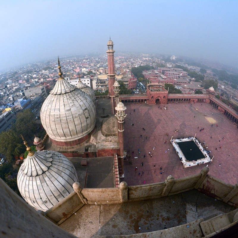
Shah Jahan (1627–57) transferred his capital from Agra to Delhi in 1648 and built a magnificent city, Shahjahanabad, considered to be the seventh city of Delhi. On October 6, 1650, the foundation stone of Jama Masjid was laid. Two gifted architects—Ustad Hamid and Ustad Ahmed Lahori were the principal architects of Shah Jahan, associated with the designing and construction of Shahjahanabad, Red Fort and Jama Masjid. Hamid was also the main architect of the Taj Mahal in Agra. Shahjahanabad or Old Delhi, as it is referred to now, shares its basic features with other old cities of pre-Partition India, such as Lucknow, Hyderabad and Lahore—all cities from the medieval era. The cities had a few basic characteristics—the centrality of the Mosque, the bazaar around it, with very distinct socio-economic strata spread out from the center to the periphery; a city wall and citadel, intra urban quarters, blind alleys and numerous other unique features.
An extensive, spatial and hierarchical organisation allowed the diverse population to live together. Some of the Sharia principles were followed by differentiating the city’s space into public, semi-private and private space. A wall and moat ran around the city. Public spaces were the main roads, the secondary roads and the bazaars. Within the city, the Mohallahs[i] were homogenous, closed units, and were therefore semi-private spaces—while the houses with courtyards were private spaces separated from the outside world, by a gate.
The name of a Mohallah was often after the name of the individual whose Haveli dominated that neighbourhood, or according to the occupation of the people who lived there (For example, Chandiwalo ki Gali, Mohalla Dhobiyan, Haveli Azam Khan, etc.). One fundamental element affecting the physical structure and organisation of the city was the legal system of the time.[ii]
Some scholars also refer to Shahjahanabad as an Islamic city as they observe the connection between the city structure and Islamic law. Citing Tunis as an example, Hakim established the influential character of Islamic law on the city’s morphology. He concluded[iii], ‘…all cities in the Arab and Islamic world inhabited predominantly by Muslims share an Islamic identity which is directly due to the application of Sharia values in the process of city building…’ It is true that Islamic law lastingly dominated the organisation and distribution of space and therefore had a direct influence on the city structure. The division of the city into small homogenous units (mohallahs); and also the subdivision of space into public, semi private and private space, which is to be seen at every level, is in conformity with this very legal system, which eventually defined the character of the Islamic city[iv].
The attributes that most of these medieval and ‘Islamic’ cities shared were palaces, chowks, masjids, mohallas—with narrow, winding streets, blind alleys and houses with internal courtyards. The roads are distinguished by their relative width, and not, as in the case of Islamic cities, by their access to private/semi private and public spaces. These attributes are similar to most medieval cities built by the Mughals. Inside the houses, there is segregation of gender maintained by having separate areas for men and women (Mardana and Zanana respectively). Houses had vast courtyards for family meetings, gatherings and recreation.
Naidu describes the typical Islamic city[v], which is walled with several gates. The main primary streets are extensions of the inter-urban trunk roads, and pass-through these gates cross at the central area where the main mosque or Jama Masjid is located. Near the mosque, the administrative area or palace usually occupies the centre of the city. Along the key primary streets, the major markets or bazaars are located in a neatly laid out linear pattern. Often two-storied buildings are found along the main roads, with residences on the floors above the shops. Secondary streets separate one mohalla from the other. Less significant bazaars, which sell restricted articles are situated along the secondary streets. When a secondary street meets with two or more such streets coming from different mohallas, a chowk is formed. Around the chowk, the character of the street changes—from residential to commercial activity, or even the presence of a religious structure like a temple or mosque in the vicinity can be noticed. Inner lanes branch into the mohallas from the secondary streets which divide the mohallas. Intricate street patterns generally negotiable either on foot or a bicycle are formed by these streets. Some of these inner lanes turn into blind alleys, which form the approach road to a group of houses. These streets or alleys are often constricted, dark and private. This kind of structuring with public and private space differentiation, gives the residents the desired degree of privacy. Hence, a walled city resident walks from an inner courtyard’s complete privacy to a lesser degree of privacy provided by the narrow lanes and familiar faces—till he enters the busy public streets.
Mosques have always been an important feature in a medieval Islamic city. Shahjahanabad was built around the twin foci of the palace/fort and the Jama Masjid. Besides the main mosque of the city, there were several other important mosques built by prominent members of the royal court. The mohallah or neighbourhood mosques were the third group of mosques. They served the people in their immediate vicinity and were built by prominent or wealthy residents of the respective Mohallahs or by guilds of merchants or artisans. All of the smaller mosques received their income through religious endowments.
Malik[vi] talks about Shahjahanabad’s hierarchy of mosques. He says that the internal hierarchy of mosques was a part of the concept of the city, a fact which becomes evident from the emperor’s allocation of land to the shurafa (nobles). The eight elite (begumi-amiri) mosques constructed by notables succeeded the royal mosque, Jami (Jama) Masjid. They were—the Masjid Fatahpuri, Sunehari Masjid, Masjid Sirhindi, Masjid Akbarabadi, Masjid Aurangabadi, Zinat al Masjid, Masjid Sharif ad-Dawlah and Fakhrul Masjid (all were built between 1650–1728). About 200 mohallah mosques stood at the end of this so-called hierarchy. Most of these were constructed by influential traders, high-ranking Mughal officers and religious scholars. Sometimes they were even located within the haveli (mansion) of a member of the shurafa. Perhaps the builders of these mosques were associated with a professional group who lived and worked there. Mostly located on ‘secondary streets’, these mosques often bear the names of their founders. Some of the mosques of higher social ranking are named after the professions active in these localities, e.g. Qadizadon ki Masjid (mosque of the Qazis) or Masjid Teliyan (mosque of Telis [oil makers]).
More socially recognised professions were settled closer to the core of the city, for example—the weavers, producers of wool, traders of saddle-horses, oil-extractors and manufacturers of straw goods—each of them represented by their respective mosques.
Malik[vii] explains about the social groups living on the periphery of the city. Professional groups (like shepherds and butchers) delivering fresh agrarian/meat products to the city, who needed quick access to these goods, had settled along the southern and south-western rim of the city (Delhi Gate and Turkman Gate). Their mosques were also located here, e.g., Masjid Gadariyon (shepherds’ mosque), Masjid Qasai or Masjid Qassab (butchers’ mosque). Masjid Dhobiyan (near Lal Miyanka Chhatta) indicates that the washer men also used to live in this area. The ‘low ranking’ trades—the potters, metal workers, masons, the coalers, etc. can be found in the narrow lanes and mosques of the south western part of the city. Malik also mentions the mohallah-mosques built and financed by immigrants, e.g., the Punjabis who had mainly Hanafite affiliations (Masjid Punjabiyan) and used to live near the Kabuli Gate, within the Punjabi Katrah[viii]. Accordingly, the Akbarabadi Masjid became known as the Masjid Kashmiri Katrah, as Kashmiri traders had settled near it.
The following conclusions can be drawn about the spatial distribution within Shahjahanabad: mosques of different sizes were laid out according to the hierarchical structure of the city, which was outlined with groups of ‘high ranking’ trades close to the core, and the less esteemed trades and professions in greater distance to it. Thus each group, according to its professional and social affiliation, occupied specific areas, within the hierarchically arranged city, symbolising a specific sacred institution, for example, the hierarchy of the mosque[ix].
Shahjahanabad, consequently also displayed different ‘Islams’—reflecting manifold economic, social and political interests and diversities (lower class practicing customs of pre-conversion period/bidat, close to Sufi teachings—and higher caste Ashrafs seen moving towards Wahabi Islam).
Castes/occupation-based groups and their residences showed a congruency of caste and class. Rich and upper caste Ashrafs were situated in the middle of the city—while the lower ranking, poor were on the periphery—much like the Hindu village structure based on the caste system. The poor strata usually lived close to the city walls (especially at the Delhi Gate, the Turkman Gate and at the Ajmeri Gate in the south, Farashkhanah in the west and Mori Gate in the north west). Their neighbours were the processing professions and tradesmen, and finally came the rich high ranking strata at Chandni Chowk and its bazaars in the middle of the city.
Kashmere Gate, Ajmeri Gate, Delhi Gate and Turkman Gate provided the entry points to Shahjahanabad. It follows the example of the segregation of the caste system of earlier times where lower castes were assigned the backward, out of the city residences. The houses near Delhi Gate and Turkman Gate, indicated the poverty of the residents (most of the residents belonged to kumhar, butcher, rangrez [dyers of cloth], chamar [this caste alone in Delhi was Muslim by religion], Teli, Gadhewala [donkey owners’] communities). All of them were Arzals, who lived near the periphery while the middle of the city was dominated by Ashrafs—mostly the nobles and other professionals who belonged to the upper castes.
Even today, some feeling of superiority amongst the residents of the central parts of Shahjahanabad (like Ballimaran, Jama Masjid, etc.) is found; who feel that the lower caste, backward, illiterate people stay in ‘fringe’ areas like Turkman Gate. The areas near the gates are still considered dominated by backward, illiterate and criminal elements, a reason often cited by residents of the central part of Shahjahanabad to avoid the ‘fringe’ areas. For example, Mehboob Alam, who is a resident of Ballimaran, a Sheikh by caste, does not allow women of his family to visit Turkman Gate alone, as he feels that notorious criminal elements stay there. He believes women here are more into immoral acts, and says that the Gadhewala and Teli women play roles in smuggling and other activities. He is also against the idea of someone from his family marrying in this part of Shahjahanabad. The ‘endogamy’ principle of caste can be observed as Arzals lived in the peripheral areas of Shahjahanabad and Ashrafs mostly lived in the middle part of Shahjahanabad, as mentioned above. Although now, with migration, influence of Tablighi Jama’at and their encouragement of inter-caste marriages and other factors, the caste equations and population compositions have changed.
Pressures have increased on Shahjahanabad. Structures of the old city are under tremendous stress with its growing population. A 17th century city built for a population of 60,000, covering an area of about 7.12 sq km, is now supporting an estimated 19,625 people per sq.km to 26,683 people per sq.km (as per Census 2011, which has increased even more now). The residential and wholesale commercial markets have grown exponentially but the cultural experience it offers is still unparalleled.
Notes
[i]Mohallas refer to a sub-division spatially forming a pattern of quarters, divided and embedded with complex social inter-relations and socially, primarily residential. Before the coming of Britishers the production and reproduction units were not separate. Most of the mohallas belonged to dominant service groups settled there (artisans, traders, craftsmen, ethnic groups). For example, Mohalla e Muftiyan (quarter of religious scholars), Mohalla e Teliyan (quarter of oil extracters), Mohalla e Dhobiyan (washerman’s quarter), Mohalla e Saudagaran (trader’s quarter), Punjabi Mohalla (Punjabi quarter), Mohalla e Sui Walan (quarter of those producing needles), Mohalla e Gadariyan (Shepherd’s quarter) and others. Katra was often inside a mohalla and often a market (for example, Marwari Katra or quarter of those who had come from Marwar) with small street (referred to as gali or kucha) were the adjoining functional streets (for example, Gali Gurwalonki (lane of jiggery producers), Gali Chandiwali (street of silver-makers) and so on. The complex social classification through the primary, secondary or tertiary streets based on their distance from the core of the city is not possible through their reference to the mohalla/katra/kucha alone as it was rarely that only one group of professionals lived there. Dominated but not exclusive as different group of artisans also stayed in the quarters. For example, at Maliwara (gardener’s quarter) various groups of artisans stayed as well. (Malik, 2003)
[ii]Ehlers and Krafft, ‘Contemporary Old Delhi’.
[iii] Hakim, Arabic-Islamic Cities
[iv] Ehlers and Krafft, ‘Contemporary Old Delhi’.
[v] Naidu, Old Cities.
[vi]Mailk, ‘Islamic Institutions and Infrastructure’.
[vii]Ibid
[viii] Different social and ethnic groups aligned their buildings and the adjoining streets functionally. A katra often inside a mohalla, small streets (gali or kucha) can be found as well; usually they also bear the names of the corresponding occupations or ethnic groups, e.g. Gali Gur walonki (lane of those producing or selling raw sugar, jaggery), Gandhi Gali (lane of flower vendors), Imam ki Gali (preachers’ lane), Rampuriyon ki Gali (lane of people belonging to Rampur) and so on. Primary, secondary and tertiary streets were based on the increasing distance to the core of the mohallah, more representative and broader but also increasingly socially anonymous the lines of communication. Social and professional classification is not possible through reference to the mohallahs alone, as only in rare cases was a mohallah the exclusive of just one group or professions: the Mohallah-e-Rodgran (quarter of the gut workers) in the west, e.g. or the Maliwara (gardeners’ quarter) in an easterly direction gave shelter to different groups of artisans in just one quarter (Malik, 2003).
[ix]Malik, ‘Islamic Institutions and Infrastructure’.
References
Ehlers, Eckart and Krafft, Thomas. ‘Islamic Cities in India’. In Shahjahanabad/Old Delhi, edited by Eckart Ehlers and Thomas Krafft. New Delhi: Manohar, 2003.
Goodfriend, Douglas, E. ‘Changing Concepts of Caste and Status among Old Delhi Muslims’. In Modernization and Social Change among Muslims in India, edited by Imtiaz Ahmad.New Delhi: Manohar, 1983.
Gupta, Narayani. Delhi Between Two Empires. New Delhi: Oxford University Press, 1981.
Gupta, Narayani. The Indomitable City in Shahjahanabad/Old Delhi, edited by Eckart Ehlers and Thomas Krafft. New Delhi: Manohar, 2003.
Hakim, B.S. Arabic-Islamic Cities: Building and Planning Principles. London: KPI, 1986.
Krafft, Thomas. ‘Contemporary Old Delhi: Transformation of an Historical Place’. In Shahjahanabad/Old Delhi, edited by Eckart Ehlers and Thomas Krafft. New Delhi: Manohar, 2003.
Malik, Jamal. ‘Islamic Institutions and Infrastructure in Shahjahanabad’. In Shahjahanabad/Old Delhi, edited by Eckart Ehlers and Thomas Krafft. New Delhi: Manohar, 2003.
Malone, Lourraine and Barton Gaynor. Old Delhi. New Delhi: Rupa and Co.,1988.
Mann, Michael. ‘Planning and Urban Resistance in the Old city of Delhi’. In Urbanization and Governance in India, edited by Evelin Hust and Michael Mann. New Delhi: Manohar, 2005.
Mitra, Asok. Delhi-Capital City. New Delhi: Thomson Press, 1970.
Naidu, Ratna. Old Cities, New Predicaments: A Study of Hyderabad. New Delhi: Sage, 1990.
Rizvi, S.M. Akram. ‘Kinship and Industry among the Muslim Karkhanedars’. In Delhi in Family, Kinship and Marriage among Muslims in India, edited by Imtiaz Ahmad. New Delhi: Manohar, 1976.
Saiyed, A.R. ‘Purdah Family Structure and the Status of Woman’. In Family, Kinship and Marriage among Muslims in India, edited by Imtiaz Ahmad. New Delhi: Manohar, 1976.
Weiss, Anita M. ‘The Gendered Division of Space in the Walled City of Lahore’. In Women–Myth and Realities, edited by Kishwar Naheed. Lahore: Sang-e-Meel Publications, 1993.